IMAGES TAKEN NEAR TO
Theobald Street, BOREHAMWOOD, WD6 4DF
Introduction
This page details the photographs taken nearby to Theobald Street, WD6 4DF by members of the Geograph project.
The Geograph project started in 2005 with the aim of publishing, organising and preserving representative images for every square kilometre of Great Britain, Ireland and the Isle of Man.

There are currently over 7.5m images from over14,400 individuals and you can help contribute to the project by visiting https://www.geograph.org.uk
Image Map
Images are licensed for reuse under creativecommons.org/licenses/by-sa/2.0
Notes
- Clicking on the map will re-center to the selected point.
- The higher the marker number, the further away the image location is from the centre of the postcode.
Image Listing (72 Images Found)
Images are licensed for reuse under creativecommons.org/licenses/by-sa/2.0
Image
Details
Distance
1
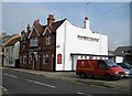
Borehamwood: The Wellington
The Wellington is on the east side of Theobald Street.
Image: © Nigel Cox
Taken: 14 Oct 2009
0.01 miles
2
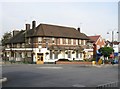
Borehamwood: The Crown
Old Ordnance Survey maps of the 1870s show that Borehamwood had a Crown Inn at that time probably serving as the station hotel, but it was set a little way further north down the hill to the left in Theobald Street. The current building from the 1920s/1930s occupies a more prominent site at the junction of Theobald Street and Shenley Road. At one time in the not too distant past it was known as The Enigma but under the new ownership of Juniper Inns it has now reverted to The Crown. According to their website branded Juniper Inns will be located in low profile but densely populated locations and principally target the 25+ age group.
Image: © Nigel Cox
Taken: 14 Oct 2009
0.02 miles
3

The Crown
The Crown public house at Elstree.
Image: © Peter McDermott
Taken: 1 Aug 2009
0.05 miles

5
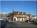
Sainsbury's Local, Borehamwood
A Sainsbury's Local shop in Borehamwood. The building was previously a pub.
Image: © Malc McDonald
Taken: 4 Nov 2022
0.05 miles
6
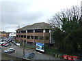
Regent House, Borehamwood
Office block near rye railway station.
Image: © JThomas
Taken: 18 Mar 2017
0.06 miles
8
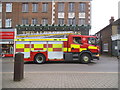
Fire engine on Shenley Road, Borehamwood
Image: © David Howard
Taken: 25 Nov 2017
0.07 miles
10
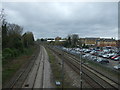
Railway towards St Albans
Looking north west from the bridge on Allum Lane (B5378).
Image: © JThomas
Taken: 18 Mar 2017
0.07 miles