IMAGES TAKEN NEAR TO
Holt Close, BOREHAMWOOD, WD6 3QH
Introduction
This page details the photographs taken nearby to Holt Close, WD6 3QH by members of the Geograph project.
The Geograph project started in 2005 with the aim of publishing, organising and preserving representative images for every square kilometre of Great Britain, Ireland and the Isle of Man.

There are currently over 7.5m images from over14,400 individuals and you can help contribute to the project by visiting https://www.geograph.org.uk
Image Map
Images are licensed for reuse under creativecommons.org/licenses/by-sa/2.0
Notes
- Clicking on the map will re-center to the selected point.
- The higher the marker number, the further away the image location is from the centre of the postcode.
Image Listing (68 Images Found)
Images are licensed for reuse under creativecommons.org/licenses/by-sa/2.0
Image
Details
Distance
1
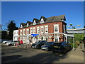
Allum Manor, Borehamwood
Allum Manor is a manor house, parts of which date from the 17th Century, in Borehamwood. More information about the house can be found on the Allum Manor website: https://www.allummanor.co.uk/key-information/our-history
Image: © Malc McDonald
Taken: 4 Nov 2022
0.05 miles
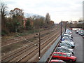
2
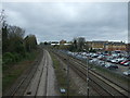
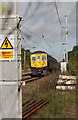
Railway towards St Albans
Looking north west from the bridge on Allum Lane (B5378).
Image: © JThomas
Taken: 18 Mar 2017
0.05 miles
3
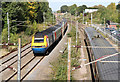
Midland Line at Elstree & Borehamwood
A view of the line from Allum Lane bridge looking north. A St.Pancras bound East Midland Trains HST with 43073 leading passes a northbound stopping service for St.Albans.
Image: © Martin Addison
Taken: 16 Oct 2012
0.06 miles
4
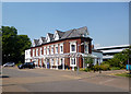
Allum Manor Community Centre
Grade 2 listed, with a modern hall behind, both available for hire.
Image: © Des Blenkinsopp
Taken: 17 Jul 2013
0.06 miles
5
Sutton Service
A First Capital Connect Class 319 (319374) approaches Elstree & Borehamwood station with a stopping service for Sutton.
Image: © Martin Addison
Taken: 16 Oct 2012
0.07 miles

7
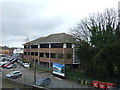
Regent House, Borehamwood
Office block near rye railway station.
Image: © JThomas
Taken: 18 Mar 2017
0.08 miles
8
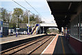
Elstree & Borehamwood station
Looking north. This shows Platforms 4 (left) and 3. Platforms 1 and 2 out of view on the right.
Image: © Dr Neil Clifton
Taken: 15 Apr 2010
0.09 miles
9
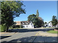
Looking across Allum Lane
This view from Deacon's Hill Road looks across Allum Lane. It is just round the corner from Elstree & Borehamwood station which is along Allum Lane to the left.
Image: © Marathon
Taken: 26 Sep 2018
0.09 miles
10
North of Elstree Station
The Midland mainline makes a gentle curve to the west as it leaves Elstree station. The black smudge in the distance behind the trees in the centre of the picture is smoke from the oil terminal fire at Hemel Hempstead. It can be seen drifting to the west (left in the photo).
Image: © David Squire
Taken: 13 Dec 2005
0.09 miles