IMAGES TAKEN NEAR TO
Butterfly Lane, BOREHAMWOOD, WD6 3AE
Introduction
This page details the photographs taken nearby to Butterfly Lane, WD6 3AE by members of the Geograph project.
The Geograph project started in 2005 with the aim of publishing, organising and preserving representative images for every square kilometre of Great Britain, Ireland and the Isle of Man.

There are currently over 7.5m images from over14,400 individuals and you can help contribute to the project by visiting https://www.geograph.org.uk
Image Map (Loading...)


Getting Data...Please wait
Leaflet Map data © OpenStreetMap
Images are licensed for reuse under creativecommons.org/licenses/by-sa/2.0
Notes
- Clicking on the map will re-center to the selected point.
- The higher the marker number, the further away the image location is from the centre of the postcode.
Image Listing (9 Images Found)
Images are licensed for reuse under creativecommons.org/licenses/by-sa/2.0
Image
Details
Distance
1
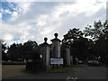
The north entrance to Haberdasher's Aske's school on Butterfly Lane
Image: © David Howard
Taken: 13 Sep 2012
0.01 miles
2
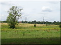
Grazing near Slades Farm
Off Butterfly Lane.
Image: © JThomas
Taken: 3 Aug 2019
0.11 miles
3
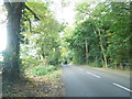
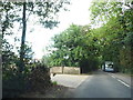
Butterfly Lane, Aldenham
Slade Farm is on the left
Image: © David Howard
Taken: 13 Sep 2012
0.13 miles
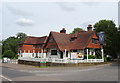
5

Sign for the Battle Axes, Radlett
See Image] for context.
Image: © JThomas
Taken: 3 Aug 2019
0.14 miles

7
Butterfly Lane at the entrance to Slade Farm
I am guessing the coach is coming to collect pupils from Haberdasher's school just behind here.
Image: © David Howard
Taken: 13 Sep 2012
0.17 miles
8
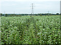
Footpath through a field of beans
A way was cleared, but is vanishing because of little use.
Image: © Robin Webster
Taken: 14 Jun 2015
0.21 miles
