IMAGES TAKEN NEAR TO
Lullington Garth, BOREHAMWOOD, WD6 2HF
Introduction
This page details the photographs taken nearby to Lullington Garth, WD6 2HF by members of the Geograph project.
The Geograph project started in 2005 with the aim of publishing, organising and preserving representative images for every square kilometre of Great Britain, Ireland and the Isle of Man.

There are currently over 7.5m images from over14,400 individuals and you can help contribute to the project by visiting https://www.geograph.org.uk
Image Map
Images are licensed for reuse under creativecommons.org/licenses/by-sa/2.0
Notes
- Clicking on the map will re-center to the selected point.
- The higher the marker number, the further away the image location is from the centre of the postcode.
Image Listing (3 Images Found)
Images are licensed for reuse under creativecommons.org/licenses/by-sa/2.0
Image
Details
Distance
1
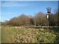
Borehamwood: Woodcock Hill Millennium Beacon
The view north-north-westwards from here extends for many miles over Borehamwood and way beyond, but is now generally obstructed in every other direction, including southwards where it ends abruptly with the scrubby trees visible in the photograph. The sign hanging off the beacon is now faded but does show Hertsmere District Council's logo.
Image: © Nigel Cox
Taken: 7 Mar 2015
0.13 miles
2
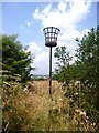
Millennium Beacon on Woodcock Hill
At around 140 metres aod this is the highest point for some distance around here.
It was chosen as a site for a semaphore telegraph station in the Napoleonic wars and for this beacon to mark the millennium.
Image: © Des Blenkinsopp
Taken: 17 Jul 2013
0.13 miles
3
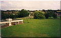
The Fire Research Station (1)
Looking towards the main entrance at the junction of Melrose Avenue and Vale Avenue, now the junction with Wordsworth Gardens which roughly follows the site roads seen in the picture.
Image: © John Webb
Taken: Unknown
0.23 miles