IMAGES TAKEN NEAR TO
Stratfield Road, BOREHAMWOOD, WD6 1XB
Introduction
This page details the photographs taken nearby to Stratfield Road, WD6 1XB by members of the Geograph project.
The Geograph project started in 2005 with the aim of publishing, organising and preserving representative images for every square kilometre of Great Britain, Ireland and the Isle of Man.

There are currently over 7.5m images from over14,400 individuals and you can help contribute to the project by visiting https://www.geograph.org.uk
Image Map (Loading...)


Getting Data...Please wait
Leaflet Map data © OpenStreetMap
Images are licensed for reuse under creativecommons.org/licenses/by-sa/2.0
Notes
- Clicking on the map will re-center to the selected point.
- The higher the marker number, the further away the image location is from the centre of the postcode.
Image Listing (19 Images Found)
Images are licensed for reuse under creativecommons.org/licenses/by-sa/2.0
Image
Details
Distance
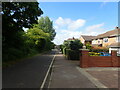
1
Theobald Street, Borehamwood
Red Lodge is on the right
Image: © David Howard
Taken: 9 Dec 2011
0.09 miles
2
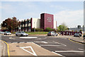
Kinetic Business Centre
Located beside Theobald Street in Borehamwood, the centre provides serviced office space.
Image: © Martin Addison
Taken: 21 Apr 2011
0.12 miles
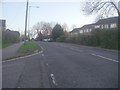
3
Theobald Street, Borehamwood
The main part of Theobald Street runs parallel to this service road on the other side of the trees on the left
Image: © Marathon
Taken: 25 May 2022
0.12 miles
4

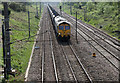
North of Elstree
A class 25 brings an engineering train north. New colour light signalling is being installed along the line and presumably the train is being moved in preparation of the weekend's planned work. Meanwhile, the line continues to be controlled by semaphore signals.
Elstree station is behind the bridge in the distance, which carries Allum Lane over the railway. The gas holders are beside Station Road.
Image: © Martin Addison
Taken: Unknown
0.15 miles
5
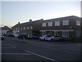
Businesses on Theobald Street, Borehamwood
Image: © David Howard
Taken: 9 Dec 2011
0.15 miles
6

London's Waste
A class 45 crosses from the slow to the fast lines with a train of refuse containers on route to a midlands landfill site. The crossover used by this train is no longer visible in the aerial photographs and was removed when the line was electrified. Higher speed crossovers between all lines were installed further north a little before Radlett Station. The gas holders in the distance are located beside Station Road and Elstree Station is hidden behind the Allum Lane bridge, visible behind the train.
Image: © Martin Addison
Taken: Unknown
0.16 miles
7
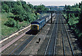
Empty Hopper Train
A class 66 diesel locomotive brings a train of empty aggregates hoppers north through the outskirts of Borehamwood. Elstree & Borehamwood station is behind the bridge in the distance.
Image: © Martin Addison
Taken: 21 Apr 2011
0.17 miles
8
Footbridge and Express
A northbound express passes under a lattice girder footbridge on the midland line, north of Elstree. I'm not sure why the express is using the slow lines. The line has been electrified since this photo was taken and the footbridge has been removed.
Image: © Martin Addison
Taken: Unknown
0.17 miles
9
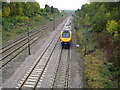
Borehamwood: Midland mainline railway
Thirty years after Martin's Image and the scenery and the train have changed quite markedly. As Martin says the footbridge has gone and the electrification infrastructure has been in place for many years now. Here a northbound East Midlands express train has just passed through Elstree & Borehamwood station and is hurtling towards the Red Road bridge.
And for them that needs to know such things the unit number is 222018.
Image: © Nigel Cox
Taken: 14 Oct 2009
0.17 miles
10
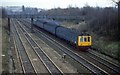
Midland Main line before electrification
A St Pancras to Bedford dmu just north of Elstree station in the days before the line was electified and the old style signals were still in place.There were two bridges sthat crossed the line just north of the station in those days.Now overhead wires spoil the view.
Image: © roger geach
Taken: Unknown
0.18 miles