IMAGES TAKEN NEAR TO
Whitehouse Avenue, BOREHAMWOOD, WD6 1HE
Introduction
This page details the photographs taken nearby to Whitehouse Avenue, WD6 1HE by members of the Geograph project.
The Geograph project started in 2005 with the aim of publishing, organising and preserving representative images for every square kilometre of Great Britain, Ireland and the Isle of Man.

There are currently over 7.5m images from over14,400 individuals and you can help contribute to the project by visiting https://www.geograph.org.uk
Image Map (Loading...)


Getting Data...Please wait
Leaflet Map data © OpenStreetMap
Images are licensed for reuse under creativecommons.org/licenses/by-sa/2.0
Notes
- Clicking on the map will re-center to the selected point.
- The higher the marker number, the further away the image location is from the centre of the postcode.
Image Listing (29 Images Found)
Images are licensed for reuse under creativecommons.org/licenses/by-sa/2.0
Image
Details
Distance
2
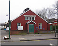
Borehamwood: Village Hall
Looking just a little in need of a coat of paint, this is Borehamwood's Village Hall, built in 1920, on Shenley Road.
Image: © Nigel Cox
Taken: 29 Mar 2007
0.16 miles
3
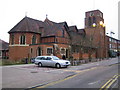
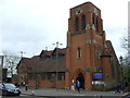
Borehamwood: All Saints Church
Construction of this Church in Shenley Road began around 1900, when Borehamwood was only a small hamlet. The Church was completed and consecrated in 1910. Its website is here http://saintnicholas.members.beeb.net/as/index.html
(Note that the parked Mercedes car was being used by someone undertaking a council traffic survey)
Image: © Nigel Cox
Taken: 29 Mar 2007
0.16 miles
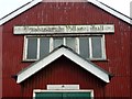
7

Borehamwood Village Hall
Built in 1920, and soon to be removed as part of a redevelopment plan
Image: © Jim Osley
Taken: 20 Mar 2011
0.18 miles
8
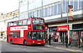
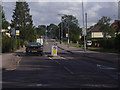
Shenley Road, Borehamwood
A London Sovereign bus on the 292 route, still wearing its previous Transdev branding, collects passengers from the Furzehill Road stop on Shenley Road. The 292 is one of two Transport for London routes serving Borehamwood - the other is the 107.
Image: © Martin Addison
Taken: 16 Oct 2012
0.19 miles
9
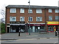
Starbucks, Borehamwood
The hoarding to the left is around a site where the last little old shops on the street have been demolished.
Image: © Robin Webster
Taken: 2 Dec 2012
0.20 miles
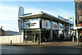
10
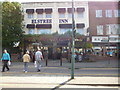
Borehamwood: The 'Hart and Spool'
Formerly the Elstree Inn
Image: © Dr Neil Clifton
Taken: 21 Sep 2016
0.20 miles