IMAGES TAKEN NEAR TO
Bulstrode Close, KINGS LANGLEY, WD4 9LT
Introduction
This page details the photographs taken nearby to Bulstrode Close, WD4 9LT by members of the Geograph project.
The Geograph project started in 2005 with the aim of publishing, organising and preserving representative images for every square kilometre of Great Britain, Ireland and the Isle of Man.

There are currently over 7.5m images from over14,400 individuals and you can help contribute to the project by visiting https://www.geograph.org.uk
Image Map
Images are licensed for reuse under creativecommons.org/licenses/by-sa/2.0
Notes
- Clicking on the map will re-center to the selected point.
- The higher the marker number, the further away the image location is from the centre of the postcode.
Image Listing (3 Images Found)
Images are licensed for reuse under creativecommons.org/licenses/by-sa/2.0
Image
Details
Distance
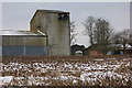
1
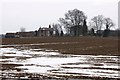
Bulstrode Farm viewed from Tower Hill
Image: © Simon Mortimer
Taken: 27 Mar 2013
0.13 miles
3
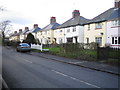
Bovingdon: Boundary Cottages
A neat row of semi-detached houses on Chipperfield Road.
Image: © Nigel Cox
Taken: 21 Jan 2006
0.22 miles