IMAGES TAKEN NEAR TO
Tower Hill, KINGS LANGLEY, WD4 9LN
Introduction
This page details the photographs taken nearby to Tower Hill, WD4 9LN by members of the Geograph project.
The Geograph project started in 2005 with the aim of publishing, organising and preserving representative images for every square kilometre of Great Britain, Ireland and the Isle of Man.

There are currently over 7.5m images from over14,400 individuals and you can help contribute to the project by visiting https://www.geograph.org.uk
Image Map
Images are licensed for reuse under creativecommons.org/licenses/by-sa/2.0
Notes
- Clicking on the map will re-center to the selected point.
- The higher the marker number, the further away the image location is from the centre of the postcode.
Image Listing (7 Images Found)
Images are licensed for reuse under creativecommons.org/licenses/by-sa/2.0
Image
Details
Distance
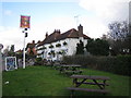
1
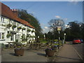
The Boot at Chipperfield, Tower Hill
There is a pair of boots, the other not far away in Sarratt
Image: © David Howard
Taken: 8 May 2012
0.08 miles
2
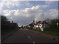
Tower Hill, Chipperfield
The Boot at Chipperfield pub is on the right, the other Boot is nearby in Sarratt
Image: © David Howard
Taken: 8 May 2012
0.10 miles
4
Footpath by Tenements Farm
Grassy path lined by hedges. Concrete cylinders in the distance help to prevent unauthorised use of the path.
Image: © Colin Smith
Taken: 27 Sep 2009
0.17 miles
5
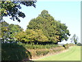
Field Near Tenements Farm
Grassy field lined by hedgerows on the north-west edge of Chipperfield village.
Image: © Colin Smith
Taken: 27 Sep 2009
0.18 miles
6
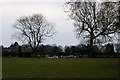
Chopped logs on the edge of the field
Looking north from the footpath off Scatterdells Lane.
Image: © Simon Mortimer
Taken: 27 Mar 2013
0.19 miles
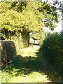
7
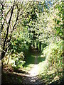
Footpath Off Dunny Lane
Narrow and leafy path, with a good surface for walkers, leading away from Chipperfield village.
Image: © Colin Smith
Taken: 27 Sep 2009
0.22 miles