IMAGES TAKEN NEAR TO
Five Acres, KINGS LANGLEY, WD4 9JU
Introduction
This page details the photographs taken nearby to Five Acres, WD4 9JU by members of the Geograph project.
The Geograph project started in 2005 with the aim of publishing, organising and preserving representative images for every square kilometre of Great Britain, Ireland and the Isle of Man.

There are currently over 7.5m images from over14,400 individuals and you can help contribute to the project by visiting https://www.geograph.org.uk
Image Map
Images are licensed for reuse under creativecommons.org/licenses/by-sa/2.0
Notes
- Clicking on the map will re-center to the selected point.
- The higher the marker number, the further away the image location is from the centre of the postcode.
Image Listing (27 Images Found)
Images are licensed for reuse under creativecommons.org/licenses/by-sa/2.0
Image
Details
Distance
1
NEW
Vicarage Lane heading west into the sunset
Image: © Philip Jeffrey
Taken: 9 Mar 2025
0.07 miles
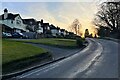
2
Vicarage Lane, Kings Langley
A view down Vicarage Lane in Kings Langley.
Image: © Malc McDonald
Taken: 26 Sep 2015
0.08 miles
3
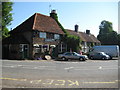
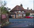
Kings Langley: Old Palace
Not the Royal Palace, the site of which is here Image, but a pub in the hamlet of Kings Langleyhill, as it is described on old Ordnance Survey maps. The pub is 17th century so post-dates the demise of the Royal Palace by at least 100 years.
Image: © Nigel Cox
Taken: 31 May 2009
0.09 miles
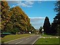
4

NEW
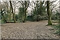
Footpath into Kings Langley Common
Image: © Philip Jeffrey
Taken: 9 Mar 2025
0.10 miles
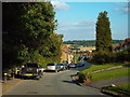
5
Vicarage Lane, Kings Langley
This image was taken in late September. The leaves on the trees are starting to turn golden.
Image: © Malc McDonald
Taken: 26 Sep 2015
0.11 miles
6
"Old Palace" public house and restaurant, King's Langley
Image: © Jim Osley
Taken: 10 Mar 2018
0.13 miles
7
NEW
Footpath to Vicarage Lane through Kings Langley Common
Image: © Philip Jeffrey
Taken: 9 Mar 2025
0.14 miles
8
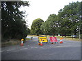
Love Lane is closed, Kings Langley
This was nothing compared with the two mile diversion ahead in Watford.
Image: © David Howard
Taken: 18 Aug 2016
0.14 miles
9
Kings Langley: Site of the former Royal Palace
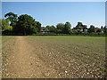
The former Royal Palace at Kings Langley was built under the supervision of Eleanor of Castile (1241 - 1290), wife of King Edward I. It appears to have been started around 1276 and to have been completed by 1299. This is how the village of Langley got its epithet Kings. Edmund de Langley, the first Duke of York and fifth son of King Edward III, was born here in 1341. Around 1349, during the outbreak of plague, known as the Black Death, King Edward III used the Royal Palace as his seat of government away from London. The Palace seems to have fallen into disuse during the Wars of the Roses, and was demolished around 1469. Apart from occasional underground finds during construction works for the nearby Image nothing remains of the former structure.
The Ordnance Survey 1:10,000 scale map shows the centre of the site to be in the rear gardens of the houses in the photograph, probably the second house from the right being where the actual symbol is. This photograph was taken from the footpath leading south.
Image: © Nigel Cox
Taken: 31 May 2009
0.14 miles
10
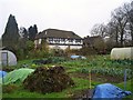
The Priory and allotments, Kings Langley
The surviving building of the former Dominican priory established in 1308 by Edward II, next to the Royal Palace of Kings Langley. Although much restored this is the only surviving building from the medieval palace complex. It is now part of Rudolph Steiner School, Kings Langley and is used for staff accommodation. The foreground allotments are also part of the school.
Image: © Graham Hale
Taken: 21 Nov 2009
0.14 miles