IMAGES TAKEN NEAR TO
Bottom Lane, KINGS LANGLEY, WD4 9AJ
Introduction
This page details the photographs taken nearby to Bottom Lane, WD4 9AJ by members of the Geograph project.
The Geograph project started in 2005 with the aim of publishing, organising and preserving representative images for every square kilometre of Great Britain, Ireland and the Isle of Man.

There are currently over 7.5m images from over14,400 individuals and you can help contribute to the project by visiting https://www.geograph.org.uk
Image Map
Images are licensed for reuse under creativecommons.org/licenses/by-sa/2.0
Notes
- Clicking on the map will re-center to the selected point.
- The higher the marker number, the further away the image location is from the centre of the postcode.
Image Listing (3 Images Found)
Images are licensed for reuse under creativecommons.org/licenses/by-sa/2.0
Image
Details
Distance
1
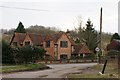
Cottage at Buck's Hill Bottom
On the corner of Chandler's Lane and Bottom Lane.
Image: © Simon Mortimer
Taken: 27 Mar 2013
0.01 miles
2
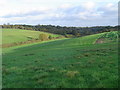
Sarratt: Buckshill Bottom valley
A dry valley viewed looking eastwards from a footpath to Newhall Farm near Sarratt.
Image: © Nigel Cox
Taken: 13 Nov 2005
0.08 miles
3
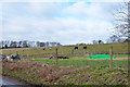
Hillside with ponies
Above Bottom Lane.
Image: © Robin Webster
Taken: 1 Feb 2015
0.10 miles