IMAGES TAKEN NEAR TO
Edmund Mews, KINGS LANGLEY, WD4 8GB
Introduction
This page details the photographs taken nearby to Edmund Mews, WD4 8GB by members of the Geograph project.
The Geograph project started in 2005 with the aim of publishing, organising and preserving representative images for every square kilometre of Great Britain, Ireland and the Isle of Man.

There are currently over 7.5m images from over14,400 individuals and you can help contribute to the project by visiting https://www.geograph.org.uk
Image Map
Images are licensed for reuse under creativecommons.org/licenses/by-sa/2.0
Notes
- Clicking on the map will re-center to the selected point.
- The higher the marker number, the further away the image location is from the centre of the postcode.
Image Listing (76 Images Found)
Images are licensed for reuse under creativecommons.org/licenses/by-sa/2.0
Image
Details
Distance
1
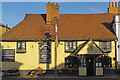
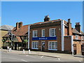
The Saracen's Head, Kings Langley
This pub on Kings Langley High Street dates from at least 1619.
Image: © Stephen McKay
Taken: 31 Oct 2018
0.02 miles
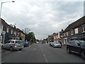
4
(Part of) High Street, WD4
Shows the location of Image
How on earth did they get planning permission for that hideous sign on such a lovely old building?
Image: © Mike Quinn
Taken: 24 Jul 2012
0.03 miles
5
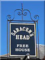
Sign for The Saracen's Head, High Street, WD4
See Image
Image: © Mike Quinn
Taken: 24 Jul 2012
0.03 miles
6
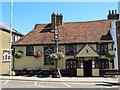
The Saracen's Head, High Street, WD4
See also Image
Image: © Mike Quinn
Taken: 24 Jul 2012
0.03 miles
8
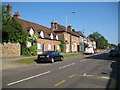
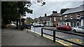
Kings Langley: High Street
At one time this road formed a section of the Sparrows Herne turnpike that ran between London and Aylesbury from 1762 to 1872. It later became part of the busy arterial A41 trunk road, but with the opening of the Kings Langley Bypass to the west of the village, the road was downgraded to the A4251 and now only carries local traffic.
Image: © Nigel Cox
Taken: 31 May 2009
0.04 miles
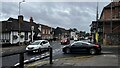
9
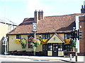
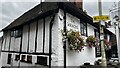
The Saracen, Kings Langley
Attractive old inn with floral display on the eastern side of the village's High Street.
http://www.kingslangley.org/
Image: © Colin Smith
Taken: 27 Sep 2009
0.04 miles