IMAGES TAKEN NEAR TO
Great Park, KINGS LANGLEY, WD4 8EB
Introduction
This page details the photographs taken nearby to Great Park, WD4 8EB by members of the Geograph project.
The Geograph project started in 2005 with the aim of publishing, organising and preserving representative images for every square kilometre of Great Britain, Ireland and the Isle of Man.

There are currently over 7.5m images from over14,400 individuals and you can help contribute to the project by visiting https://www.geograph.org.uk
Image Map
Images are licensed for reuse under creativecommons.org/licenses/by-sa/2.0
Notes
- Clicking on the map will re-center to the selected point.
- The higher the marker number, the further away the image location is from the centre of the postcode.
Image Listing (58 Images Found)
Images are licensed for reuse under creativecommons.org/licenses/by-sa/2.0
Image
Details
Distance
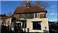
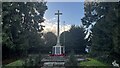
4
Church grounds, All Saints Church, Church Lane
Image: © Bryn Holmes
Taken: 11 Dec 2023
0.06 miles
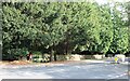
6
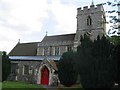
C of E Church Kings Langley
I took a fancy to the red door
Image: © Jack Hill
Taken: 15 Jul 2005
0.06 miles
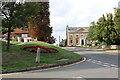
7
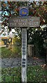
Village of the Year West award sign, Kings Langley
Image: © Bryn Holmes
Taken: 11 Dec 2023
0.06 miles
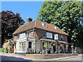
9
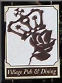
Sign for The Rose and Crown, High Street, WD4
See Image
Image: © Mike Quinn
Taken: 24 Jul 2012
0.06 miles
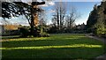
10
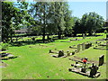
All Saints Church, Kings Langley - cemetery
See Image
Image: © Mike Quinn
Taken: 24 Jul 2012
0.07 miles