IMAGES TAKEN NEAR TO
Osbourne Avenue, KINGS LANGLEY, WD4 8DD
Introduction
This page details the photographs taken nearby to Osbourne Avenue, WD4 8DD by members of the Geograph project.
The Geograph project started in 2005 with the aim of publishing, organising and preserving representative images for every square kilometre of Great Britain, Ireland and the Isle of Man.

There are currently over 7.5m images from over14,400 individuals and you can help contribute to the project by visiting https://www.geograph.org.uk
Image Map
Images are licensed for reuse under creativecommons.org/licenses/by-sa/2.0
Notes
- Clicking on the map will re-center to the selected point.
- The higher the marker number, the further away the image location is from the centre of the postcode.
Image Listing (20 Images Found)
Images are licensed for reuse under creativecommons.org/licenses/by-sa/2.0
Image
Details
Distance
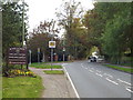
1
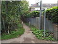
Public footpath, Kings Langley
A public footpath in Kings Langley, Hertfordshire. Concrete bollards prevent cars from attempting to use the path.
Image: © Malc McDonald
Taken: 26 Sep 2015
0.15 miles

8
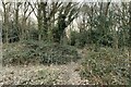
NEW
Footpath into Kings Langley Common
Image: © Philip Jeffrey
Taken: 9 Mar 2025
0.17 miles
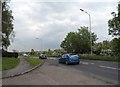
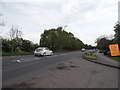
9
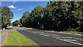
Hempstead Road, Kings Langley
The electronic sign warns an approaching motorist to slow down as the road enters Kings Langley.
Image: © Malc McDonald
Taken: 26 Sep 2015
0.17 miles
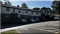
10

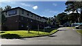
Kings Langley Methodist Church
The church is set in a plot off the west side of Hempstead Road.
Image: © Nigel Cox
Taken: 31 May 2009
0.17 miles