IMAGES TAKEN NEAR TO
Bradbery, RICKMANSWORTH, WD3 9UB
Introduction
This page details the photographs taken nearby to Bradbery, WD3 9UB by members of the Geograph project.
The Geograph project started in 2005 with the aim of publishing, organising and preserving representative images for every square kilometre of Great Britain, Ireland and the Isle of Man.

There are currently over 7.5m images from over14,400 individuals and you can help contribute to the project by visiting https://www.geograph.org.uk
Image Map
Images are licensed for reuse under creativecommons.org/licenses/by-sa/2.0
Notes
- Clicking on the map will re-center to the selected point.
- The higher the marker number, the further away the image location is from the centre of the postcode.
Image Listing (11 Images Found)
Images are licensed for reuse under creativecommons.org/licenses/by-sa/2.0
Image
Details
Distance
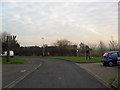
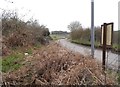
2
Maple Cross: Longcroft Road
Viewed looking westwards.
Image: © Nigel Cox
Taken: 31 Dec 2005
0.11 miles
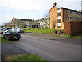
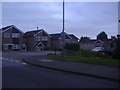
4
Buttlehide
Man walks dog in Maple Cross.
Image: © Burgess Von Thunen
Taken: 17 Jan 2012
0.13 miles
7
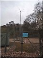
NATS navigation aerial, Maple Cross
This is used for aircraft to locate where they are.
Image: © David Howard
Taken: 3 Apr 2018
0.14 miles
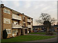
8
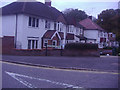
Houses on the corner of Woodland Road and Hornhill Road
Image: © David Howard
Taken: 2 Nov 2011
0.15 miles
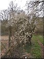
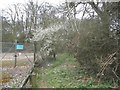
10
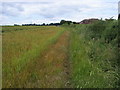
Footpath nearing houses
Footpath nearing houses in The Hawthorns Maple Cross
Image: © Shaun Ferguson
Taken: 13 Jun 2008
0.20 miles