IMAGES TAKEN NEAR TO
Uxbridge Road, RICKMANSWORTH, WD3 8XA
Introduction
This page details the photographs taken nearby to Uxbridge Road, WD3 8XA by members of the Geograph project.
The Geograph project started in 2005 with the aim of publishing, organising and preserving representative images for every square kilometre of Great Britain, Ireland and the Isle of Man.

There are currently over 7.5m images from over14,400 individuals and you can help contribute to the project by visiting https://www.geograph.org.uk
Image Map
Images are licensed for reuse under creativecommons.org/licenses/by-sa/2.0
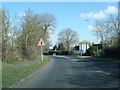
Notes
- Clicking on the map will re-center to the selected point.
- The higher the marker number, the further away the image location is from the centre of the postcode.
Image Listing (36 Images Found)
Images are licensed for reuse under creativecommons.org/licenses/by-sa/2.0
Image
Details
Distance
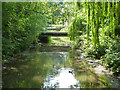
2
The River Colne downstream of Drayton Ford Bridge
Photo taken from the Image
Image: © Mike Quinn
Taken: 7 Aug 2019
0.05 miles
3
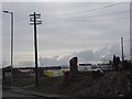
Traditional telegraph pole on Uxbridge Road, Mill End
Image: © David Howard
Taken: 3 Apr 2018
0.05 miles
4
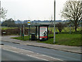
Long Lane bus stop
The first bus stop coming into Rickmansworth on Uxbridge Road.
Image: © Robin Webster
Taken: 27 Mar 2013
0.06 miles
5
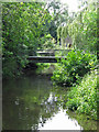
River Colne backwater at Drayton Ford
Looking from the bridge that replaced the ford, apparently some time ago. The bridge in view is internal to a waterworks. A July view - for the same view in March, see Image .
Image: © Robin Webster
Taken: 17 Jul 2013
0.06 miles
7
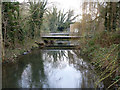
River Colne backwater at Drayton Ford
Looking from the bridge that replaced the ford, apparently some time ago. The bridge in view is internal to a waterworks.
Image: © Robin Webster
Taken: 27 Mar 2013
0.06 miles
8

Drayton Ford Bridge on Springwell Lane (2)
See also Image The Image is in the vegetation just beyond the sign marking the boundary between Three Rivers District and the London Borough of Hillingdon.
Image: © Mike Quinn
Taken: 7 Aug 2019
0.08 miles
9

Drayton Ford Bridge on Springwell Lane
Shows the location of Image - lower left, by the poles of the modern road sign which can be seen in Image
Image: © Mike Quinn
Taken: 7 Aug 2019
0.08 miles
10
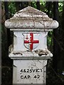
Coal tax boundary post no.62, Springwell Lane (detail)
See Image and Image Here, remnants of two of the fixing screws for the correction plate can be seen, one below the initial "4" and the other below the "2" in the second line of the inscription.
Image: © Mike Quinn
Taken: 7 Aug 2019
0.08 miles