IMAGES TAKEN NEAR TO
Tudor Way, RICKMANSWORTH, WD3 8JB
Introduction
This page details the photographs taken nearby to Tudor Way, WD3 8JB by members of the Geograph project.
The Geograph project started in 2005 with the aim of publishing, organising and preserving representative images for every square kilometre of Great Britain, Ireland and the Isle of Man.

There are currently over 7.5m images from over14,400 individuals and you can help contribute to the project by visiting https://www.geograph.org.uk
Image Map
Images are licensed for reuse under creativecommons.org/licenses/by-sa/2.0
Notes
- Clicking on the map will re-center to the selected point.
- The higher the marker number, the further away the image location is from the centre of the postcode.
Image Listing (6 Images Found)
Images are licensed for reuse under creativecommons.org/licenses/by-sa/2.0
Image
Details
Distance
1
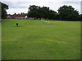
Playing field by Mill End school
Playing field by Mill End school on Shepherds Lane
Image: © Shaun Ferguson
Taken: 18 Jul 2008
0.15 miles
2
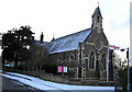
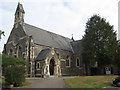
Rickmansworth: St Peter's Church, Berry Lane, Mill End
A Church of England church built in 1875, there is a modern Roman Catholic Church on the opposite side of Berry Lane.
Image: © Nigel Cox
Taken: 27 Dec 2005
0.16 miles
3
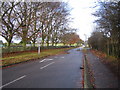
Rickmansworth: Shepherds Lane, Mill End
Traffic calming measures in place looking north westwards along Shepherds Lane with the William Penn Sports Arena to the left.
Image: © Nigel Cox
Taken: 31 Dec 2005
0.18 miles
4
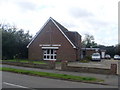
Berry Lane Methodist Church, Rickmansworth
This church in Berry Lane opened in May, 1964 and is in the Watford Circuit. Its postcode is WD3 7HJ.
Image: © David Hillas
Taken: 1 Oct 2008
0.22 miles
5
Church of St Peter the Apostle, Rickmansworth
Image: © Richard Rogerson
Taken: 17 Sep 2009
0.22 miles
6
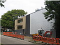
William Penn Leisure Centre, Rickmansworth
Image: © Richard Rogerson
Taken: 17 Sep 2009
0.24 miles