IMAGES TAKEN NEAR TO
Chenies Road, RICKMANSWORTH, WD3 6EW
Introduction
This page details the photographs taken nearby to Chenies Road, WD3 6EW by members of the Geograph project.
The Geograph project started in 2005 with the aim of publishing, organising and preserving representative images for every square kilometre of Great Britain, Ireland and the Isle of Man.

There are currently over 7.5m images from over14,400 individuals and you can help contribute to the project by visiting https://www.geograph.org.uk
Image Map
Images are licensed for reuse under creativecommons.org/licenses/by-sa/2.0
Notes
- Clicking on the map will re-center to the selected point.
- The higher the marker number, the further away the image location is from the centre of the postcode.
Image Listing (21 Images Found)
Images are licensed for reuse under creativecommons.org/licenses/by-sa/2.0
Image
Details
Distance
1
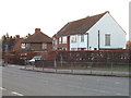
Houses on Chenies Road, Chorleywood
Taken looking south near St Clement Danes school
Image: © David Hawgood
Taken: 17 Feb 2006
0.03 miles
2
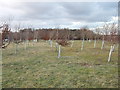
Young trees at North Hill, Chorleywood
In a triangle of roads opposite St Clement Dane's School
Image: © David Hawgood
Taken: 17 Feb 2006
0.05 miles
3
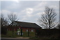
Barbarolli Hall, St Clement's Dane School
Image: © N Chadwick
Taken: 3 Apr 2013
0.06 miles