IMAGES TAKEN NEAR TO
Bottom Lane, RICKMANSWORTH, WD3 6DL
Introduction
This page details the photographs taken nearby to Bottom Lane, WD3 6DL by members of the Geograph project.
The Geograph project started in 2005 with the aim of publishing, organising and preserving representative images for every square kilometre of Great Britain, Ireland and the Isle of Man.

There are currently over 7.5m images from over14,400 individuals and you can help contribute to the project by visiting https://www.geograph.org.uk
Image Map (9 Images)


Getting Data...Please wait
Leaflet Map data © OpenStreetMap
Images are licensed for reuse under creativecommons.org/licenses/by-sa/2.0
Notes
- Clicking on the map will re-center to the selected point.
- The higher the marker number, the further away the image location is from the centre of the postcode.
Image Listing (9 Images Found)
Images are licensed for reuse under creativecommons.org/licenses/by-sa/2.0
Image
Details
Distance
1
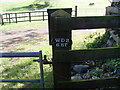
Postcode Disc, Commonwood
This photo shows the postcode "WD3 6BT" on a black disc which refers to Bottom Lane, Commonwood where the photo was taken. It is by a metal gate leading into a field.
Image: © David Hillas
Taken: 3 May 2014
0.03 miles
2
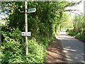
Public Footpath Sign, Commonwood
This photo, taken in Bottom Lane, shows the public footpath sign to "Sarratt Green ½" plus the Wildlife notice. However, the triangular sign indicating wildlife seems to be missing here.
Image: © David Hillas
Taken: 3 May 2014
0.03 miles
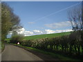
4
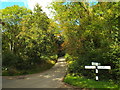
Country lanes near Sarratt
A junction of country lanes, with a traditional wooden signpost, in woodland near Sarratt in western Hertfordshire.
Image: © Malc McDonald
Taken: 26 Sep 2015
0.12 miles
5
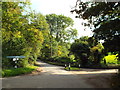
Road junction near Sarratt
A junction near Sarratt, in western Hertfordshire.
Image: © Malc McDonald
Taken: 26 Sep 2015
0.12 miles
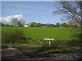
6
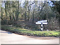
Commonwood Common
Crossroads finger post on Commonwood Common at the junction of Red Lion Lane (to Sarratt), Plough Lane (to Belsize), Commonwood Lane (to Commonwood), and Bottom Lane (to Chandlers Cross).
Image: © Nigel Cox
Taken: 29 Jan 2006
0.15 miles
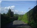
8
Deadmans Ash Lane at the junction of Bottom Lane
Image: © David Howard
Taken: 8 May 2012
0.18 miles