IMAGES TAKEN NEAR TO
Wyatts Road, RICKMANSWORTH, WD3 5TB
Introduction
This page details the photographs taken nearby to Wyatts Road, WD3 5TB by members of the Geograph project.
The Geograph project started in 2005 with the aim of publishing, organising and preserving representative images for every square kilometre of Great Britain, Ireland and the Isle of Man.

There are currently over 7.5m images from over14,400 individuals and you can help contribute to the project by visiting https://www.geograph.org.uk
Image Map
Images are licensed for reuse under creativecommons.org/licenses/by-sa/2.0
Notes
- Clicking on the map will re-center to the selected point.
- The higher the marker number, the further away the image location is from the centre of the postcode.
Image Listing (63 Images Found)
Images are licensed for reuse under creativecommons.org/licenses/by-sa/2.0
Image
Details
Distance
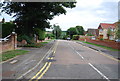
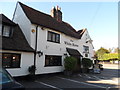
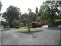
3
Wyatts Road at the junction of Amersham Road
Image: © David Howard
Taken: 14 Apr 2018
0.14 miles
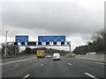
5
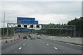
Giant gantry
M25 heading anti-clockwise approaching junction with the A404. The extra lane work is almost complete.
Image: © Mr Ignavy
Taken: 3 Aug 2010
0.14 miles
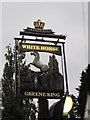
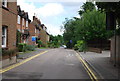
8
Wyatts Close
Bungalows in Chorleywood.
Image: © Burgess Von Thunen
Taken: 6 Sep 2012
0.15 miles
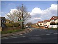
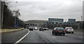
9
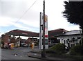
The Shell petrol station on Rickmansworth Road, Chorleywood
Image: © David Howard
Taken: 19 May 2015
0.15 miles