IMAGES TAKEN NEAR TO
Heronsgate Road, RICKMANSWORTH, WD3 5PA
Introduction
This page details the photographs taken nearby to Heronsgate Road, WD3 5PA by members of the Geograph project.
The Geograph project started in 2005 with the aim of publishing, organising and preserving representative images for every square kilometre of Great Britain, Ireland and the Isle of Man.

There are currently over 7.5m images from over14,400 individuals and you can help contribute to the project by visiting https://www.geograph.org.uk
Image Map
Images are licensed for reuse under creativecommons.org/licenses/by-sa/2.0
Notes
- Clicking on the map will re-center to the selected point.
- The higher the marker number, the further away the image location is from the centre of the postcode.
Image Listing (17 Images Found)
Images are licensed for reuse under creativecommons.org/licenses/by-sa/2.0
Image
Details
Distance


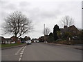
3
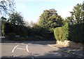
Heronsgate Road at the junction of Shire Lane
Image: © David Howard
Taken: 19 Sep 2014
0.07 miles

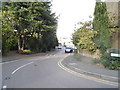
7
Chalfont Lane at the junction of Shire Lane
Image: © David Howard
Taken: 19 Sep 2014
0.13 miles
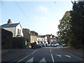
9
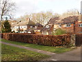
Chalfont Lane, Chorleywood
An area of detached houses. The lane has a wide grass verge.
Image: © David Hawgood
Taken: 17 Feb 2006
0.15 miles
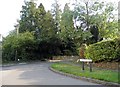
10
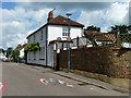
Former beer house, Heronsgate Road
Now a private house.
Image: © Robin Webster
Taken: 5 Jun 2014
0.17 miles