IMAGES TAKEN NEAR TO
Nottingham Road, RICKMANSWORTH, WD3 5DB
Introduction
This page details the photographs taken nearby to Nottingham Road, WD3 5DB by members of the Geograph project.
The Geograph project started in 2005 with the aim of publishing, organising and preserving representative images for every square kilometre of Great Britain, Ireland and the Isle of Man.

There are currently over 7.5m images from over14,400 individuals and you can help contribute to the project by visiting https://www.geograph.org.uk
Image Map
Images are licensed for reuse under creativecommons.org/licenses/by-sa/2.0
Notes
- Clicking on the map will re-center to the selected point.
- The higher the marker number, the further away the image location is from the centre of the postcode.
Image Listing (14 Images Found)
Images are licensed for reuse under creativecommons.org/licenses/by-sa/2.0
Image
Details
Distance
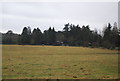
1
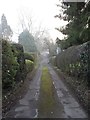
Nottingham Road
More of a track than a road in Heronsgate.
Image: © Burgess Von Thunen
Taken: 17 Jan 2012
0.01 miles
2
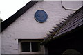
Chartist hero
The blue plaque on the village hall in Heronsgate commemorates its origins as O'Connorville.
Image: © S Parish
Taken: 13 May 2007
0.01 miles
3
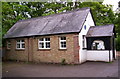
Heronsgate hall
The village hall in Heronsgate, once the Chartist experiment of O'Connorville.
Image: © S Parish
Taken: 13 May 2007
0.02 miles
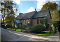
4
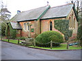
Heronsgate: St. John's Church
Heronsgate was the first estate developed by the Chartists in 1845 and was initially named O'Connorville after their leader, Feargus O'Connor. 35 cottages and a school were built. Town-dwellers from the north of England were re-settled initially at subsidised rents and the street names, Stockport Road, Nottingham Road, Halifax Road and Bradford Road reflect their origins. The ban on alcohol which was imposed at that time gave rise to the nearby public house being named "The Land of Liberty, Peace and Plenty". An image of this pub is here ImageThis image is of the small church dedicated to St. John at the junction of Stockport Road and Halifax Road North.
Image: © Nigel Cox
Taken: 31 Dec 2005
0.06 miles
6
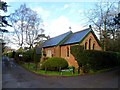
St John's Church Heronsgate
The church originally served the Chartist settlement of Heronsgate. Chartist settlements date from around 1845. Their aim was to set up factory workers with small holdings so that they would become eligible to vote. Looking at the 1:25000 OS map of Heronsgate today, it is obvious that it was originally laid out as a number of small plots suitable for agriculture. It is ironic that for a settlement developed to help the poor working class, the current residents are among the most affluent in the country.
Image: © Bikeboy
Taken: 23 Mar 2014
0.12 miles
7
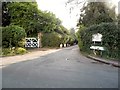
Stockport Road at the junction of Long Lane
The entrance to a private estate.
Image: © David Howard
Taken: 19 Sep 2014
0.14 miles
9
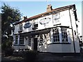
The Land of Liberty, Peace and Plenty Pub, Heronsgate
Image: © David Howard
Taken: 19 Sep 2014
0.16 miles
10
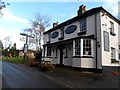
The Land of Liberty, Peace and Plenty Pub
The unusual name is a nod to the Chartist history of the settlement of Heronsgate. See http://www.geograph.org.uk/photo/3900099 for more information.
Image: © Bikeboy
Taken: 23 Mar 2014
0.18 miles