IMAGES TAKEN NEAR TO
Olleberrie Lane, RICKMANSWORTH, WD3 4NU
Introduction
This page details the photographs taken nearby to Olleberrie Lane, WD3 4NU by members of the Geograph project.
The Geograph project started in 2005 with the aim of publishing, organising and preserving representative images for every square kilometre of Great Britain, Ireland and the Isle of Man.

There are currently over 7.5m images from over14,400 individuals and you can help contribute to the project by visiting https://www.geograph.org.uk
Image Map
Images are licensed for reuse under creativecommons.org/licenses/by-sa/2.0
Notes
- Clicking on the map will re-center to the selected point.
- The higher the marker number, the further away the image location is from the centre of the postcode.
Image Listing (6 Images Found)
Images are licensed for reuse under creativecommons.org/licenses/by-sa/2.0
Image
Details
Distance
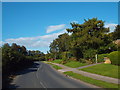
1
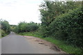
Dunny's Lane, Belsize
Dunny's Lane, heading out of the village of Belsize in west Hertfordshire.
Image: © Malc McDonald
Taken: 26 Sep 2015
0.21 miles
2
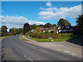
Dwellings in Dunny Lane, Belsize
Belsize is a hamlet built along the east side of a Chiltern dry valley and consists of mainly post-War houses.
Image: © David Kemp
Taken: 17 Jul 2023
0.21 miles
3
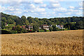
Dunny's Lane, approaching Chipperfield
Dunny's Lane, heading into the village of Chipperfield in western Hertfordshire.
Image: © Malc McDonald
Taken: 26 Sep 2015
0.22 miles
4
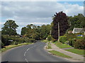
Dunny Lane, Belsize
A view north along Dunny Lane, heading out of the village of Belsize.
Image: © Malc McDonald
Taken: 26 Sep 2015
0.23 miles
5
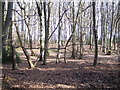
Belsize: Woodman's Wood
Beech woodland at the eastern end of the wood, named after the nearby Woodman's Farm one suspects.
Image: © Nigel Cox
Taken: 5 Mar 2006
0.23 miles