IMAGES TAKEN NEAR TO
Finches Avenue, RICKMANSWORTH, WD3 4LN
Introduction
This page details the photographs taken nearby to Finches Avenue, WD3 4LN by members of the Geograph project.
The Geograph project started in 2005 with the aim of publishing, organising and preserving representative images for every square kilometre of Great Britain, Ireland and the Isle of Man.

There are currently over 7.5m images from over14,400 individuals and you can help contribute to the project by visiting https://www.geograph.org.uk
Image Map
Images are licensed for reuse under creativecommons.org/licenses/by-sa/2.0
Notes
- Clicking on the map will re-center to the selected point.
- The higher the marker number, the further away the image location is from the centre of the postcode.
Image Listing (5 Images Found)
Images are licensed for reuse under creativecommons.org/licenses/by-sa/2.0
Image
Details
Distance
1
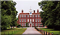
Redheath, Watford
An accomplished Georgian house, dated 1712, topped by a cupola (possibly added in 1743). The mix of brown brick and red brick for the dressings is very satisfying. Grade II* listed.
The house, built for Charles Finch, is now used as a prep school, York House.
The date of the photo is uncertain.
Image: © Stephen Richards
Taken: Unknown
0.03 miles
2
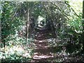
Sarratt: Footpath between Redheath and Cassiobury Park
The footpath is a green tunnel through here.
Image: © Nigel Cox
Taken: 26 Sep 2018
0.11 miles
3
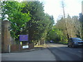
The entrance to York House school, Sarratt Road
Image: © David Howard
Taken: 8 May 2012
0.15 miles
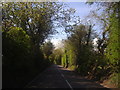
5
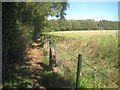
Sarratt: Footpath between Croxley Green and Chandler's Cross
This is the view looking north towards Chandler's Cross, with Harrocks Wood in view on the right.
Image: © Nigel Cox
Taken: 26 Sep 2018
0.24 miles