IMAGES TAKEN NEAR TO
Armitage Close, RICKMANSWORTH, WD3 4HL
Introduction
This page details the photographs taken nearby to Armitage Close, WD3 4HL by members of the Geograph project.
The Geograph project started in 2005 with the aim of publishing, organising and preserving representative images for every square kilometre of Great Britain, Ireland and the Isle of Man.

There are currently over 7.5m images from over14,400 individuals and you can help contribute to the project by visiting https://www.geograph.org.uk
Image Map
Images are licensed for reuse under creativecommons.org/licenses/by-sa/2.0
Notes
- Clicking on the map will re-center to the selected point.
- The higher the marker number, the further away the image location is from the centre of the postcode.
Image Listing (4 Images Found)
Images are licensed for reuse under creativecommons.org/licenses/by-sa/2.0
Image
Details
Distance
1
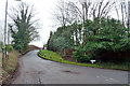
Junction of Sarratt Lane with Loudwater Lane
Looking from Sarratt Lane, which continues as Loudwater Lane, also the name of the road joining on the right.
Image: © Robin Webster
Taken: 25 Jan 2015
0.06 miles
2
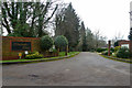
Entrance, Loudwater Ridge
A small development of large houses.
Image: © Robin Webster
Taken: 25 Jan 2015
0.11 miles
3
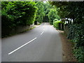
Loudwater Lane
Loudwater Lane heading over the River Chess bridge
Image: © Shaun Ferguson
Taken: 18 Jul 2008
0.24 miles
4
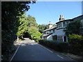
House on Loudwater Lane
The River Chess is split into two branches for a short distance here and the bridge over the northernmost of the two is just beyond this white house.
Image: © Marathon
Taken: 18 Sep 2019
0.24 miles