IMAGES TAKEN NEAR TO
Watford Road, RICKMANSWORTH, WD3 3RX
Introduction
This page details the photographs taken nearby to Watford Road, WD3 3RX by members of the Geograph project.
The Geograph project started in 2005 with the aim of publishing, organising and preserving representative images for every square kilometre of Great Britain, Ireland and the Isle of Man.

There are currently over 7.5m images from over14,400 individuals and you can help contribute to the project by visiting https://www.geograph.org.uk
Image Map
Images are licensed for reuse under creativecommons.org/licenses/by-sa/2.0
Notes
- Clicking on the map will re-center to the selected point.
- The higher the marker number, the further away the image location is from the centre of the postcode.
Image Listing (74 Images Found)
Images are licensed for reuse under creativecommons.org/licenses/by-sa/2.0
Image
Details
Distance
2
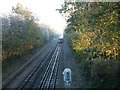
Underground train overground by Croxley
A London underground train approaching Croxley Station from Watford.
Image: © Jim Bain
Taken: 18 Nov 2005
0.05 miles
3
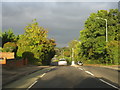
Croxley Rail Link (1): Baldwins Lane
In July 2013 The Secretary of State for Transport issued a Transport and Works Act Order for the proposed Croxley Rail Link scheme granting the planning permissions, access rights and land transfers necessary for the scheme to go ahead. The £118m scheme proposes that the current London Underground Metropolitan Line branch to Watford would be re-routed from a point east of Croxley station and extended to Watford Junction station via Watford High Street station, with the closure of the original Watford station to passenger traffic. It is proposed that new stations would be provided on the new rail link at Ascot Road, where a park and ride facility would be provided, and at Vicarage Road, in order to serve Watford General Hospital, the proposed Watford Health Campus development, and Watford Football Club. Construction work is scheduled to commence in 2014 with completion planned for 2016. The Croxley Rail Link's website is here http://www.croxleyraillink.com/Default.htm
This is one of a series of pre-construction photographs, showing the current bridge over Baldwins Lane carrying the existing line to Watford. The proposed new route would start from a point a little way to the west of the bridge, with a new viaduct to be built crossing Baldwins Lane here and then running all the way to the Ascot Road station.
Image: © Nigel Cox
Taken: 4 Aug 2013
0.06 miles
4
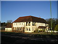
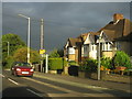
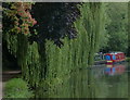
The Harvester Pub, Croxley Green, Rickmansworth
Watford Road, Croxley Green, Rickmansworth, WD3 3RX close to the canal
Image: © canalandriversidepubs co uk
Taken: Unknown
0.07 miles
5
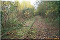
Leaves on the line!
The former Croxley Green railway station with track and a couple of lamp posts still intact. This was the end of the branch line from Watford Junction and was abandoned around 1996. The track has been completely cut, where it crossed Ascot Road about 300 metres east of here, for some time. There have been plans for many years to connect this line to the Metropolitan Line railway near Croxley station (a different station!) to provide direct rail access into the centre of Watford from the west, but nothing has so far materialized. At the time of writing Multimap helpfully tells prospective visitors to the area that this is the nearest railway station!
Image: © Nigel Cox
Taken: 27 Nov 2005
0.08 miles
6

Steps to Croxley Green Station
A casual passer-by might wonder where these steps once led to, but tightly secured Heras fencing prevents any exploration. There is no indication on site, but the peeled Network SouthEast (NSE) red paint on the lampposts is a clue; at the top of the embankment was the site of Croxley Green station.
The Croxley Green branch was opened in 1912, becoming an outpost of the DC electrified system running out of Euston and Broad Street. For much of the line's existence the service consisted of a peak hours shuttle to and from Watford Junction although in NSE days an attempt was made to increase patronage with an all-day service. This was not successful; the stations were not ideally located and the frequent bus services that passed closer to Watford's amenities were a better option for most potential customers. In the end the trains were 'temporarily' withdrawn in 1996 with a purely nominal road replacement. The trains were never reinstated and permanent withdrawal came in 2003 - a rare example of a railway closure in the post-privatisation period.
Image: © Stephen McKay
Taken: 12 Jan 2022
0.11 miles
8
Entrance to Croxley Green station, 1984
View eastward, towards Watford Junction: terminus of the ex-London & North Western electrified branch from Watford Junction/Bushey & Oxhey to Rickmansworth (Church St.), already closed since 2/1/67 (passengers 3/3/52), the service to Croxley Green was reduced on 17/5/93 to one train per day and completely from 27/3/96. A remarkably protracted end (!)
Image: © Ben Brooksbank
Taken: 7 May 1984
0.11 miles
9

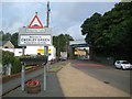
Croxley Danes School, Baldwins Lane
Located at 48 Baldwins Lane WD3 3LR, this all-ability, co-educational secondary school was
opened in September 2017, but at the St Clement Danes School site in Chorleywood (TQ0297). It
moved to its present location in September 2020 and now has over 1,200 students aged 11-18
educated there. Both schools come within the Danes Educational Trust.
Image: © David Hillas
Taken: 31 Aug 2024
0.12 miles