IMAGES TAKEN NEAR TO
Oakleigh Drive, RICKMANSWORTH, WD3 3EE
Introduction
This page details the photographs taken nearby to Oakleigh Drive, WD3 3EE by members of the Geograph project.
The Geograph project started in 2005 with the aim of publishing, organising and preserving representative images for every square kilometre of Great Britain, Ireland and the Isle of Man.

There are currently over 7.5m images from over14,400 individuals and you can help contribute to the project by visiting https://www.geograph.org.uk
Image Map
Images are licensed for reuse under creativecommons.org/licenses/by-sa/2.0
Notes
- Clicking on the map will re-center to the selected point.
- The higher the marker number, the further away the image location is from the centre of the postcode.
Image Listing (97 Images Found)
Images are licensed for reuse under creativecommons.org/licenses/by-sa/2.0
Image
Details
Distance
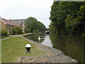
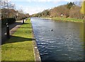
2
Bend on the Grand Union
A bend on the Grand Union by the old John Dickinsons paper mill.
Image: © Jim Bain
Taken: 18 Nov 2005
0.08 miles
5
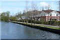
Houses at Common Moor
Just north of Common Moor lock, these houses are on a brownfield site, former industrial premises. Being canalside they are probably expected to attract premium prices.
Image: © Graham Horn
Taken: 11 Apr 2010
0.09 miles
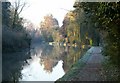
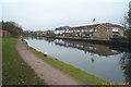
7
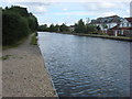
The Grand Union Canal near Common Moor Lock
This section of the Grand Union Canal from the River Thames at Brentford was opened in 1794. It was the first section of what was originally called the Grand Junction Canal. Its purpose was to provide a new, shorter and quicker transport route between London and Birmingham by connecting with a network of canals at Braunston near Daventry. When the canal reached Braunston in 1805 it cut 60 miles off the shortest alternative route.
This is the view from just east of Common Moor Lock near Croxley.
Image: © Marathon
Taken: 22 May 2019
0.10 miles
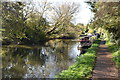
9
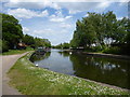
Grand Union Canal near Croxley Green
The canal upstream of Common Moor Lock is very broad. This view was taken looking in the opposite direction to Image, with the residential development on the former Dickinson paper mill site on the left.
Image: © Nigel Cox
Taken: 21 Mar 2008
0.12 miles
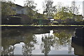
10
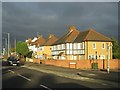
Grand Union Canal: near Croxley Common Lock
New canalside residential development replacing the old Croxley paper mill, viewed looking north eastwards from Croxley Common Lock.
Image: © Nigel Cox
Taken: 27 Nov 2005
0.12 miles