IMAGES TAKEN NEAR TO
Watford Road, RICKMANSWORTH, WD3 3BJ
Introduction
This page details the photographs taken nearby to Watford Road, WD3 3BJ by members of the Geograph project.
The Geograph project started in 2005 with the aim of publishing, organising and preserving representative images for every square kilometre of Great Britain, Ireland and the Isle of Man.

There are currently over 7.5m images from over14,400 individuals and you can help contribute to the project by visiting https://www.geograph.org.uk
Image Map
Images are licensed for reuse under creativecommons.org/licenses/by-sa/2.0
Notes
- Clicking on the map will re-center to the selected point.
- The higher the marker number, the further away the image location is from the centre of the postcode.
Image Listing (89 Images Found)
Images are licensed for reuse under creativecommons.org/licenses/by-sa/2.0
Image
Details
Distance
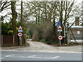
1
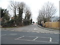
Yorke Road at the junction of Watford Road
Image: © David Howard
Taken: 20 Jan 2015
0.02 miles
3
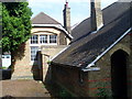
Former Yorke Road Infant School (2)
Since this school in Croxley Green closed in 1974, it has been used for various purposes. Now it lies derelict and the site may soon be redeveloped for housing. The outside toilets can be seen in the distance on the left.
Image: © David Hillas
Taken: 23 May 2009
0.04 miles
4
Former Yorke Road Infant School (1)
The village school was established here in 1875, but closed down in 1974, being replaced by Yorke Mead School, TQ0795 refers. Its postcode is WD3 3DW.
Image: © David Hillas
Taken: 23 May 2009
0.05 miles
5
Slow going on All Saints' Lane
At first a public road, the bumps start where it becomes a private access road and public footpath.
Image: © Robin Webster
Taken: 27 Mar 2013
0.06 miles
6
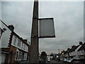
This is not a sign
There were two of these in the area I passed, and can only think they were stuck on the background, which is clearly going to lead to the obvious results with both. There's no trace of anything left stuck to it or any paint so unless someone remembers them will remain a mystery.
Image: © David Howard
Taken: 20 Jan 2015
0.07 miles
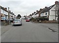
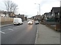
8
Dickinson Avenue at the junction of Yorke Road
Image: © David Howard
Taken: 20 Jan 2015
0.08 miles
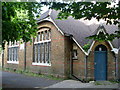
9
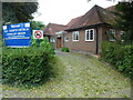
All Saints' Church Hall, Croxley Green
Situated off The Green near the A412 Watford Road, this church hall dates
from 1932. Previously, there had been a row of cottages, Berean Cottages, known once as Penny Row, and afterwards as Hero Terrace. It was in the late 1920s when they became vacant and subsequently demolished to be replaced by the new parish hall. On the left of the photo, there is a blue notice which says
'Welcome, All Saints' Church, Croxley Green', whilst adjacent to it is a
motor vehicles prohibited notice.
Image: © David Hillas
Taken: 30 Aug 2021
0.09 miles
10
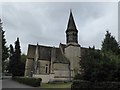
All Saints, Croxley Green: mid July 2016
Image: © Basher Eyre
Taken: 13 Aug 2016
0.09 miles