IMAGES TAKEN NEAR TO
Frankland Close, RICKMANSWORTH, WD3 3AR
Introduction
This page details the photographs taken nearby to Frankland Close, WD3 3AR by members of the Geograph project.
The Geograph project started in 2005 with the aim of publishing, organising and preserving representative images for every square kilometre of Great Britain, Ireland and the Isle of Man.

There are currently over 7.5m images from over14,400 individuals and you can help contribute to the project by visiting https://www.geograph.org.uk
Image Map
Images are licensed for reuse under creativecommons.org/licenses/by-sa/2.0
Notes
- Clicking on the map will re-center to the selected point.
- The higher the marker number, the further away the image location is from the centre of the postcode.
Image Listing (29 Images Found)
Images are licensed for reuse under creativecommons.org/licenses/by-sa/2.0
Image
Details
Distance
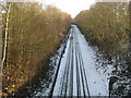
1
Metropolitan Line railway at Croxley Green
This is a repeat view of Image, this time with the remnants of the snow of 2 February 2009 still lying on the trackbed and on the sheltered cutting slope to the left. On the right the snow on the cutting bank has already melted in the sunshine.
Image: © Nigel Cox
Taken: 4 Feb 2009
0.08 miles
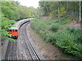
2
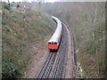
Metropolitan Line railway at Croxley Green
A southbound Metropolitan Line train for Baker Street eases around the sharp curve in the deep cutting at the Harvey Road bridge, west of Croxley station, on the Watford branch. The extension of the Metropolitan Line to Watford opened in 1925.
Image: © Nigel Cox
Taken: 15 Mar 2008
0.08 miles
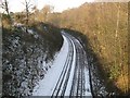
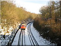
3
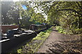
Metropolitan Line railway at Croxley Green
Viewed from the Harvey Road bridge, and picked up against the snow of 2 February 2009, the dead straight trackwork here ends in the left bend that leads to Croxley station. The line here runs in a cutting between Gonville Avenue to the left and Frankland Road to the right.
The photograph illustrates the way in which electrical power is provided to the trains. The outer and central rails are both non-running, where the former is energised at +420 volts DC, and the latter at -210 volts DC, which combine to provide a traction voltage of 630 volts DC.
Image: © Nigel Cox
Taken: 4 Feb 2009
0.14 miles
4
Former Harvey Road School, Croxley Green
Taken in July 1997, this photo shows the former primary school in Harvey Road WD3 3BN which opened in 1939. Shortly after this photo was taken, the wooden building was demolished with the replacement building being opened in September 1997 for children from reception class to year 6. A playing field now occupies the site of the former school with the present school being on the former playing field.
Image: © David Hillas
Taken: 12 Jul 1997
0.15 miles
5
Metropolitan Line railway between Watford and Moor Park
This was an attempt, following the heavy snowfall of 2 February 2009, to replicate Image taken over three years previously. Fortunately a northbound train heading for Watford duly obliged. This is the eastern side of the so-called Croxley Triangle.
Image: © Nigel Cox
Taken: 4 Feb 2009
0.18 miles
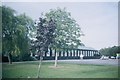
6
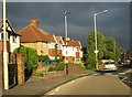
Dramatic storm skies
Watford Road, close to Harvey Road. Croxley Green.
Image: © Mr Ignavy
Taken: 24 Sep 2010
0.21 miles
8
Metropolitan Line railway between Watford and Moor Park
A northbound Metropolitan Line train approaches Croxley station on the Watford branch from the Moor Park direction (and for those who collect such things, no, I did not get its number!). This is one side of the "Croxley Triangle", and the image was taken from the overbridge by the signal box.
Image: © Nigel Cox
Taken: 23 Oct 2005
0.22 miles