IMAGES TAKEN NEAR TO
Harefield Road, RICKMANSWORTH, WD3 1PS
Introduction
This page details the photographs taken nearby to Harefield Road, WD3 1PS by members of the Geograph project.
The Geograph project started in 2005 with the aim of publishing, organising and preserving representative images for every square kilometre of Great Britain, Ireland and the Isle of Man.

There are currently over 7.5m images from over14,400 individuals and you can help contribute to the project by visiting https://www.geograph.org.uk
Image Map
Images are licensed for reuse under creativecommons.org/licenses/by-sa/2.0
Notes
- Clicking on the map will re-center to the selected point.
- The higher the marker number, the further away the image location is from the centre of the postcode.
Image Listing (24 Images Found)
Images are licensed for reuse under creativecommons.org/licenses/by-sa/2.0
Image
Details
Distance
1
Harefield Road
Image: © Mike Quinn
Taken: 7 Aug 2019
0.06 miles
2
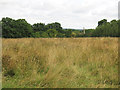
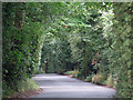
Public footpath across a field near Oakfield Farm
A path less travelled.
Image: © Mike Quinn
Taken: 7 Aug 2019
0.06 miles
3
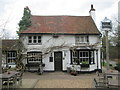
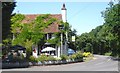
The Rose and Crown
Country pub near to Bishop's Wood Country Park.
Image: © Peter S
Taken: 24 Mar 2016
0.08 miles
4
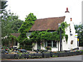
The Rose & Crown
According to the sign, more than just a pub. The bus stop cuts no nonsense - it is called 'Rose & Crown Pub'.
Image: © Robin Webster
Taken: 25 Jan 2015
0.09 miles

6
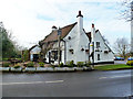
Rose & Crown, Woodcock Hill
Old traditional pub in this small patch of countryside that has somehow survived in between suburban Northwood and Rickmansworth.
Image: © Des Blenkinsopp
Taken: 23 Jul 2012
0.09 miles
9
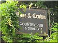
Sign for The Rose & Crown, Harefield Road
See Image
Image: © Mike Quinn
Taken: 7 Aug 2019
0.10 miles
10
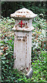
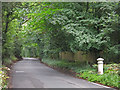
Coal tax boundary post no.58, Harefield Road / Rickmansworth Road
The location of this post is shown in Image, Image and Image See also Image
The post is Grade II listed https://historicengland.org.uk/listing/the-list/list-entry/1389527 .
There were originally nearly 280 coal tax posts located around London, of which about 210 are still extant; around 180 of these (85%) are 3 ft high white-painted square bollards with a pyramidal top, decorative raised bands, and the shield from the City of London’s arms, like this one. Photos of the coal tax posts on Geograph are at http://www.geograph.org.uk/search.php?i=86542993&page=1 .
The posts were erected under the Coal and Wine Duties (Continuation) Act of 1861 to mark the points at which duty had to be paid on coal being transported to London. The boundary was set at that of the Metropolitan Police District, and the resulting revenue was used by the Corporation of the City of London to fund public works. For further info see http://www.coaldutyposts.org.uk/cityposts.html .
Image: © Mike Quinn
Taken: 7 Aug 2019
0.10 miles