IMAGES TAKEN NEAR TO
Fairfolds, WATFORD, WD25 9UW
Introduction
This page details the photographs taken nearby to Fairfolds, WD25 9UW by members of the Geograph project.
The Geograph project started in 2005 with the aim of publishing, organising and preserving representative images for every square kilometre of Great Britain, Ireland and the Isle of Man.

There are currently over 7.5m images from over14,400 individuals and you can help contribute to the project by visiting https://www.geograph.org.uk
Image Map
Images are licensed for reuse under creativecommons.org/licenses/by-sa/2.0
Notes
- Clicking on the map will re-center to the selected point.
- The higher the marker number, the further away the image location is from the centre of the postcode.
Image Listing (15 Images Found)
Images are licensed for reuse under creativecommons.org/licenses/by-sa/2.0
Image
Details
Distance
3
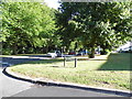
Bowmans Green at the junction of Phillipers
Image: © David Howard
Taken: 19 Sep 2012
0.17 miles
4
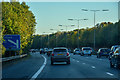
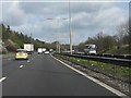
Watford : M1 Motorway
The M1 Motorway between Junction 6 (Waterdale) and Junction 5 (Berrygrove).
Image: © Lewis Clarke
Taken: 3 Oct 2018
0.19 miles
5
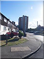
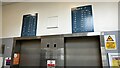
Tower block on the A41 from Phillipers
These flats can be seen from all directions when entering Watford on the A41 and surrounds.
Image: © David Howard
Taken: 19 Sep 2012
0.20 miles
6
Phillipers at the junction of The Gossamers, Meriden
Image: © David Howard
Taken: 19 Sep 2012
0.21 miles
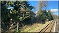
9
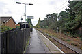
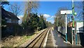
Garston Station
This halt on the Watford Junction - St Albans Abbey branch (invariably known as the 'Abbey' to railway people) was first opened in 1966 to serve an expanding district of Watford. This was unusual in a period when the emphasis was on rationalisation and closure of the railway network, and in fact the branch had been listed for closure in the infamous Beeching Report published only three years earlier.
Image: © Stephen McKay
Taken: 19 Oct 2009
0.23 miles