IMAGES TAKEN NEAR TO
Cow Lane, WATFORD, WD25 9PW
Introduction
This page details the photographs taken nearby to Cow Lane, WD25 9PW by members of the Geograph project.
The Geograph project started in 2005 with the aim of publishing, organising and preserving representative images for every square kilometre of Great Britain, Ireland and the Isle of Man.

There are currently over 7.5m images from over14,400 individuals and you can help contribute to the project by visiting https://www.geograph.org.uk
Image Map
Images are licensed for reuse under creativecommons.org/licenses/by-sa/2.0
Notes
- Clicking on the map will re-center to the selected point.
- The higher the marker number, the further away the image location is from the centre of the postcode.
Image Listing (34 Images Found)
Images are licensed for reuse under creativecommons.org/licenses/by-sa/2.0
Image
Details
Distance
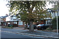
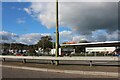
2
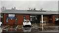
Garston Medical Centre, North Western Avenue
Image: © Bryn Holmes
Taken: 19 Dec 2023
0.05 miles
4
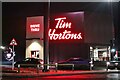
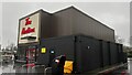
New Tim Horton's in Garston
This has replaced the Pizza Hut next to Sainsbury's on the A41 in the last year.
Image: © David Howard
Taken: 24 Dec 2022
0.07 miles
6
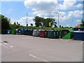
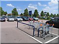
Recycling bins in Sainsbury's car park
Image: © Andrew Tatlow
Taken: 1 Jun 2009
0.10 miles
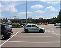
8
Sainsbury's garage on Northwestern Avenue, Watford
Image: © David Howard
Taken: 11 Oct 2020
0.11 miles
9
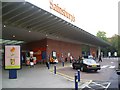
Sainsbury's Superstore, Garston
This is the second superstore in Garston. There is an Asda superstore just across the A41 200 yards away.
Image: © Graham Hale
Taken: 15 Oct 2009
0.11 miles