IMAGES TAKEN NEAR TO
Ley Farm Close, WATFORD, WD25 9BH
Introduction
This page details the photographs taken nearby to Ley Farm Close, WD25 9BH by members of the Geograph project.
The Geograph project started in 2005 with the aim of publishing, organising and preserving representative images for every square kilometre of Great Britain, Ireland and the Isle of Man.

There are currently over 7.5m images from over14,400 individuals and you can help contribute to the project by visiting https://www.geograph.org.uk
Image Map
Images are licensed for reuse under creativecommons.org/licenses/by-sa/2.0
Notes
- Clicking on the map will re-center to the selected point.
- The higher the marker number, the further away the image location is from the centre of the postcode.
Image Listing (34 Images Found)
Images are licensed for reuse under creativecommons.org/licenses/by-sa/2.0
Image
Details
Distance
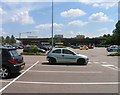
3
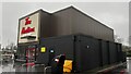
Sainsbury's Superstore, Garston
This is the second superstore in Garston. There is an Asda superstore just across the A41 200 yards away.
Image: © Graham Hale
Taken: 15 Oct 2009
0.07 miles
4
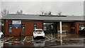
Garston Medical Centre, North Western Avenue
Image: © Bryn Holmes
Taken: 19 Dec 2023
0.08 miles
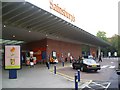
6
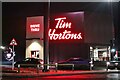
New Tim Horton's in Garston
This has replaced the Pizza Hut next to Sainsbury's on the A41 in the last year.
Image: © David Howard
Taken: 24 Dec 2022
0.09 miles
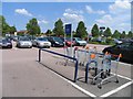
7
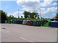
Recycling bins in Sainsbury's car park
Image: © Andrew Tatlow
Taken: 1 Jun 2009
0.10 miles
9
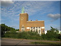
Watford: Odhams press hall
The structure is a reminder of Watford's history as a centre of the printing industry. It was built in 1954 to the designs of the architectural practice of Yates, Cook & Derbyshire and forms a prominent landmark along the A41 North Western Avenue. The massive clock tower has a purpose - it houses a tank for holding water during the printing process. The building is listed.
(Note from a purely cartographic point of view the co-ordinates given for this photo illustrate the distortion caused in the Ordnance Survey's 1:50,000 mapping by the over-emphasis on the importance of roads, and their greatly exaggerated width. The co-ordinates are taken from the much more accurate 1:10,000 scale maps.)
Image: © Nigel Cox
Taken: 20 May 2009
0.10 miles
10
Sainsbury's garage on Northwestern Avenue, Watford
Image: © David Howard
Taken: 11 Oct 2020
0.11 miles