IMAGES TAKEN NEAR TO
The Gossamers, WATFORD, WD25 9AW
Introduction
This page details the photographs taken nearby to The Gossamers, WD25 9AW by members of the Geograph project.
The Geograph project started in 2005 with the aim of publishing, organising and preserving representative images for every square kilometre of Great Britain, Ireland and the Isle of Man.

There are currently over 7.5m images from over14,400 individuals and you can help contribute to the project by visiting https://www.geograph.org.uk
Image Map
Images are licensed for reuse under creativecommons.org/licenses/by-sa/2.0
Notes
- Clicking on the map will re-center to the selected point.
- The higher the marker number, the further away the image location is from the centre of the postcode.
Image Listing (20 Images Found)
Images are licensed for reuse under creativecommons.org/licenses/by-sa/2.0
Image
Details
Distance
2

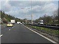
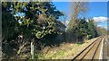
Watford : M1 Motorway
The M1 Motorway between Junction 6 (Waterdale) and Junction 5 (Berrygrove).
Image: © Lewis Clarke
Taken: 3 Oct 2018
0.07 miles
3
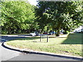
Phillipers at the junction of The Gossamers, Meriden
Image: © David Howard
Taken: 19 Sep 2012
0.13 miles
4
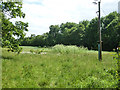
Grassy field corner near M1
The stand of a tall white flowered plant is the poisonous Hemlock. This is supposed to smell of mice. It certainly smells, but in these hygienic days it would probably be more helpful to say mice smell of Hemlock.
Image: © Robin Webster
Taken: 10 Jun 2015
0.15 miles
5
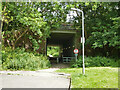
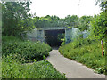
Path under M1
From the end of Falcon Way to School Lane and the Old Fox pub.
Image: © Robin Webster
Taken: 10 Jun 2015
0.18 miles
6
Path under M1
The path is from Church Lane and the Old Fox pub to the Watford conurbation beyond the M1.
Image: © Robin Webster
Taken: 10 Jun 2015
0.18 miles
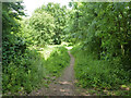
7
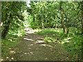
Path into old pit area
Not publicly recognized.
Image: © Robin Webster
Taken: 10 Jun 2015
0.19 miles
8
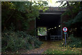
Footpath subway from Garston under the M1
This subway leads from the end of Falcon Way in Garston towards Bricket Wood Common and the Hertfordshire Way
Image: © Robert Eva
Taken: 3 Nov 2016
0.19 miles
10
Path in old pit area
Not publicly recognized.
Image: © Robin Webster
Taken: 10 Jun 2015
0.19 miles