IMAGES TAKEN NEAR TO
The Gossamers, WATFORD, WD25 9AJ
Introduction
This page details the photographs taken nearby to The Gossamers, WD25 9AJ by members of the Geograph project.
The Geograph project started in 2005 with the aim of publishing, organising and preserving representative images for every square kilometre of Great Britain, Ireland and the Isle of Man.

There are currently over 7.5m images from over14,400 individuals and you can help contribute to the project by visiting https://www.geograph.org.uk
Image Map
Images are licensed for reuse under creativecommons.org/licenses/by-sa/2.0
Notes
- Clicking on the map will re-center to the selected point.
- The higher the marker number, the further away the image location is from the centre of the postcode.
Image Listing (20 Images Found)
Images are licensed for reuse under creativecommons.org/licenses/by-sa/2.0
Image
Details
Distance
2

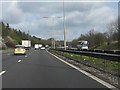
Watford : M1 Motorway
The M1 Motorway between Junction 6 (Waterdale) and Junction 5 (Berrygrove).
Image: © Lewis Clarke
Taken: 3 Oct 2018
0.10 miles
3
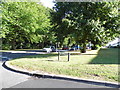
Phillipers at the junction of The Gossamers, Meriden
Image: © David Howard
Taken: 19 Sep 2012
0.11 miles
5
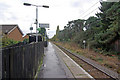
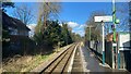
Garston Station
This halt on the Watford Junction - St Albans Abbey branch (invariably known as the 'Abbey' to railway people) was first opened in 1966 to serve an expanding district of Watford. This was unusual in a period when the emphasis was on rationalisation and closure of the railway network, and in fact the branch had been listed for closure in the infamous Beeching Report published only three years earlier.
Image: © Stephen McKay
Taken: 19 Oct 2009
0.16 miles
7
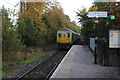
Garston station
The 08.09 to St Albans Abbey is departing. The train is a "319" unit which has been cascaded down from Thameslink services.
Image: © Robert Eva
Taken: 3 Nov 2016
0.17 miles
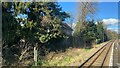
8
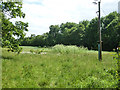
Grassy field corner near M1
The stand of a tall white flowered plant is the poisonous Hemlock. This is supposed to smell of mice. It certainly smells, but in these hygienic days it would probably be more helpful to say mice smell of Hemlock.
Image: © Robin Webster
Taken: 10 Jun 2015
0.17 miles
9
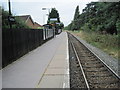
Garston (Hertfordshire) railway station
Opened in 1966 by British Rail on its line from Watford Junction to St. Albans Abbey, it was originally a short wooden platform. It is now slightly longer and slightly more substantial. View south west towards Watford North and Watford Junction.
Image: © Nigel Thompson
Taken: 13 Aug 2012
0.17 miles
10
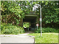
Path under M1
From the end of Falcon Way to School Lane and the Old Fox pub.
Image: © Robin Webster
Taken: 10 Jun 2015
0.18 miles