IMAGES TAKEN NEAR TO
High Cross, WATFORD, WD25 8BL
Introduction
This page details the photographs taken nearby to High Cross, WD25 8BL by members of the Geograph project.
The Geograph project started in 2005 with the aim of publishing, organising and preserving representative images for every square kilometre of Great Britain, Ireland and the Isle of Man.

There are currently over 7.5m images from over14,400 individuals and you can help contribute to the project by visiting https://www.geograph.org.uk
Image Map
Images are licensed for reuse under creativecommons.org/licenses/by-sa/2.0
Notes
- Clicking on the map will re-center to the selected point.
- The higher the marker number, the further away the image location is from the centre of the postcode.
Image Listing (3 Images Found)
Images are licensed for reuse under creativecommons.org/licenses/by-sa/2.0
Image
Details
Distance
1
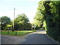
High Cross at the entrance to Edge Grove school
Image: © David Howard
Taken: 13 Sep 2012
0.00 miles
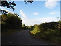
3
High Cross at the junction of Radlett Road
The road name has been changed from Oakridge Lane, changing yet again at the left turn becoming Kemprow.
Image: © David Howard
Taken: 13 Sep 2012
0.15 miles