IMAGES TAKEN NEAR TO
Aldenham, WATFORD, WD25 8AN
Introduction
This page details the photographs taken nearby to WD25 8AN by members of the Geograph project.
The Geograph project started in 2005 with the aim of publishing, organising and preserving representative images for every square kilometre of Great Britain, Ireland and the Isle of Man.

There are currently over 7.5m images from over14,400 individuals and you can help contribute to the project by visiting https://www.geograph.org.uk
Image Map
Images are licensed for reuse under creativecommons.org/licenses/by-sa/2.0
Notes
- Clicking on the map will re-center to the selected point.
- The higher the marker number, the further away the image location is from the centre of the postcode.
Image Listing (20 Images Found)
Images are licensed for reuse under creativecommons.org/licenses/by-sa/2.0
Image
Details
Distance
1
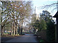
Aldenham
Church Lane, Aldenham, with the Church of St John The Baptist visible through the trees.
Image: © Nigel Cox
Taken: 10 Dec 2005
0.04 miles
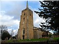
2
Aldenham: Church of St John the Baptist
There is an excellent active website for the Church here http://www.aldenhamchurch.com/index.html
Image: © Nigel Cox
Taken: 10 Dec 2005
0.04 miles
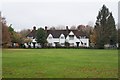
3
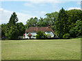
Cottages on the green, Aldenham
The centre block of a symmetrical crescent of seven arranged 2-3-2.
Image: © Robin Webster
Taken: 10 Jun 2015
0.05 miles
5
Cottages on the green, Aldenham
The northern pair of a symmetrical crescent of seven arranged 2-3-2.
Image: © Robin Webster
Taken: 10 Jun 2015
0.08 miles
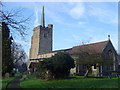
6

St John the Baptist, Aldenham
According to the church website http://www.aldenhamchurch.com/church-history.html , there are a large number of Hertfordshire pudding stones incorporated into the building which may indicate that the church was built from stones used in a pre-Christian site of worship. The first written record of the existence of the church dates from 1267. The lower part of the tower dates from C13,while a lot of the rest of the church dates from the C15.
Image: © Bikeboy
Taken: 1 Feb 2014
0.08 miles
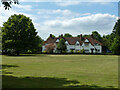
7
Aldenham green
View west from the road near the church, across the green to houses.
Image: © David Hawgood
Taken: 4 Feb 2006
0.09 miles
8
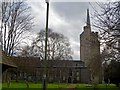
St John the Baptist, Aldenham (2)
According to the church website http://www.aldenhamchurch.com/church-history.html there are a large number of Hertfordshire pudding stones incorporated into the building which may indicate that the church was built from stones used in a pre-Christian site of worship. The first written record of the existence of the church dates from 1267. The lower part of the tower dates from C13,while a lot of the rest of the church dates from the C15.
Image: © Bikeboy
Taken: 1 Feb 2014
0.10 miles
9
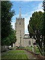
Aldenham church tower
St. John the Baptist's is a grade I listed building. The tower is originally early 13th century.
Image: © Robin Webster
Taken: 10 Jun 2015
0.10 miles
10
St John the Baptist, Aldenham (3)
According to the church website http://www.aldenhamchurch.com/church-history.html there are a large number of Hertfordshire pudding stones incorporated into the building which may indicate that the church was built from stones used in a pre-Christian site of worship. The first written record of the existence of the church dates from 1267. The lower part of the tower dates from C13,while a lot of the rest of the church dates from the C15.
Image: © Bikeboy
Taken: 1 Feb 2014
0.10 miles