IMAGES TAKEN NEAR TO
Horseshoe Lane, WATFORD, WD25 7HL
Introduction
This page details the photographs taken nearby to Horseshoe Lane, WD25 7HL by members of the Geograph project.
The Geograph project started in 2005 with the aim of publishing, organising and preserving representative images for every square kilometre of Great Britain, Ireland and the Isle of Man.

There are currently over 7.5m images from over14,400 individuals and you can help contribute to the project by visiting https://www.geograph.org.uk
Image Map
Images are licensed for reuse under creativecommons.org/licenses/by-sa/2.0
Notes
- Clicking on the map will re-center to the selected point.
- The higher the marker number, the further away the image location is from the centre of the postcode.
Image Listing (7 Images Found)
Images are licensed for reuse under creativecommons.org/licenses/by-sa/2.0
Image
Details
Distance
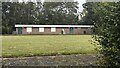
1
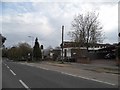
Combewood nursing home on Horseshoe Lane
Image: © David Howard
Taken: 16 Apr 2015
0.04 miles
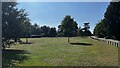
2
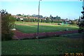
Watford: Woodside Stadium
Opened on 4 November 1955, this athletics stadium is part of the Watford Leisure Centre complex in Horseshoe Lane and is the home of Watford Harriers.
Image: © Nigel Cox
Taken: 29 Oct 2005
0.12 miles