IMAGES TAKEN NEAR TO
Paramount Industrial Estate, Sandown Road, WATFORD, WD24 7XD
Introduction
This page details the photographs taken nearby to Paramount Industrial Estate, Sandown Road, WD24 7XD by members of the Geograph project.
The Geograph project started in 2005 with the aim of publishing, organising and preserving representative images for every square kilometre of Great Britain, Ireland and the Isle of Man.

There are currently over 7.5m images from over14,400 individuals and you can help contribute to the project by visiting https://www.geograph.org.uk
Image Map (Loading...)


Getting Data...Please wait
Leaflet Map data © OpenStreetMap
Images are licensed for reuse under creativecommons.org/licenses/by-sa/2.0
Notes
- Clicking on the map will re-center to the selected point.
- The higher the marker number, the further away the image location is from the centre of the postcode.
Image Listing (23 Images Found)
Images are licensed for reuse under creativecommons.org/licenses/by-sa/2.0
Image
Details
Distance
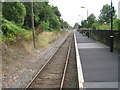
1
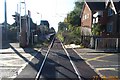
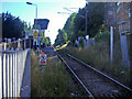
The Abbey Flyer line at Watford North station
The opposite view to the first geograph in this square, now looking south from the Bushey Mill Lane level crossing through Watford North station.
Image: © Nigel Cox
Taken: 27 Oct 2005
0.06 miles
2
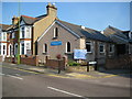
North Watford Church of the Nazarene
From Wikipedia The Church of the Nazarene is an international evangelical Christian denomination that began in the Wesleyan tradition of the 19th century Holiness movement. It was founded in the USA in 1895 and its mission is to make Christlike disciples in all countries of the world.
This is the North Watford church in Balmoral Road at its junction with Sandown Road. The foundation stone was laid in 1924. As befits an evangelical organization the church has a comprehensive website here http://www.watford-nazarene.org.uk/index.htm
Image: © Nigel Cox
Taken: 21 Sep 2008
0.12 miles
3
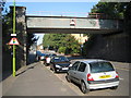
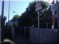
North Watford: Balmoral Road railway bridge
The bridge carries the railway from Watford Junction to St Albans Abbey over Balmoral Road. When the railway was built in 1858 this was all agricultural land. A narrow low bridge was provided through the new railway embankment for agricultural access only. This bridge with only 10' 9" headroom survived to 1960 to be a real bottleneck to traffic, until it was replaced with the current one.
Image: © Nigel Cox
Taken: 21 Sep 2008
0.13 miles
4
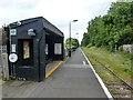
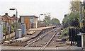
Watford North station
Looking towards Watford Junction on the St. Albans branch.
Image: © Robin Webster
Taken: 10 Jun 2015
0.14 miles
6
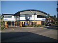
North Watford: Volvo Penta, Imperial Way
Volvo Penta opened their purpose-built UK headquarters building here in 2002. Divisions of the company located within the building include marine leisure and commercial sales, parts and accessories sales, service support and administration, accounting services and IT.
Image: © Nigel Cox
Taken: 21 Sep 2008
0.16 miles
8
Watford North station, 1984
View southward, towards Watford Junction: ex-LNWR Watford Junction - St Albans Abbey branch. The station/halt was named 'Callowlands' until 3/27.
Image: © Ben Brooksbank
Taken: 7 May 1984
0.16 miles
9
Watford North railway station
Opened in 1910 by the London and North Western Railway on its line from Watford Junction to St. Albans Abbey. View north towards Garston (Herts) and St. Albans Abbey.
Image: © Nigel Thompson
Taken: 13 Aug 2012
0.16 miles
10
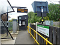
Platform approach, Watford North
On the single track branch, which has just about as intensive a service as can be achieved with one train shuttling between Watford Junction and St. Albans Abbey. The display shows the first and third trains at 12:28 and 13:20 towards Watford Junction. The second train time has scrolled off the display, but it should be the 12:48 in the other direction.
Image: © Robin Webster
Taken: 10 Jun 2015
0.16 miles