IMAGES TAKEN NEAR TO
Tudor Walk, WATFORD, WD24 7NZ
Introduction
This page details the photographs taken nearby to Tudor Walk, WD24 7NZ by members of the Geograph project.
The Geograph project started in 2005 with the aim of publishing, organising and preserving representative images for every square kilometre of Great Britain, Ireland and the Isle of Man.

There are currently over 7.5m images from over14,400 individuals and you can help contribute to the project by visiting https://www.geograph.org.uk
Image Map (Loading...)


Getting Data...Please wait
Leaflet Map data © OpenStreetMap
Images are licensed for reuse under creativecommons.org/licenses/by-sa/2.0
Notes
- Clicking on the map will re-center to the selected point.
- The higher the marker number, the further away the image location is from the centre of the postcode.
Image Listing (8 Images Found)
Images are licensed for reuse under creativecommons.org/licenses/by-sa/2.0
Image
Details
Distance
1
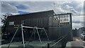
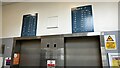
Meriden Community Centre, Garsmouth Way
Image: © Bryn Holmes
Taken: 27 Sep 2023
0.14 miles
4
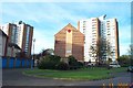
Watford: Abbey View & Munden View, Meriden Estate
Watford's only tower blocks dominate the skyline in this estate of mainly 1950s / 1960s housing (Abbey View to the right, Munden View to the left).
Image: © Nigel Cox
Taken: 5 Nov 2005
0.19 miles

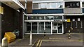
6
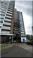
Abbey View flats post-fire, Garston, Watford
Image: © Bryn Holmes
Taken: 12 Jul 2022
0.23 miles
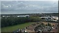
8
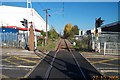
The Abbey Flyer line at Watford North station
Colloquially known as the Abbey Flyer, this single track branch line railway runs from Watford Junction station to St. Albans Abbey station, a distance of about 10 kilometres. Trains take 16 minutes to make the journey, and run every 45 minutes during the day. This view was taken looking north towards St. Albans from the Bushey Mill Lane level crossing.
Image: © Nigel Cox
Taken: 27 Oct 2005
0.24 miles