IMAGES TAKEN NEAR TO
Berry Avenue, WATFORD, WD24 6ST
Introduction
This page details the photographs taken nearby to Berry Avenue, WD24 6ST by members of the Geograph project.
The Geograph project started in 2005 with the aim of publishing, organising and preserving representative images for every square kilometre of Great Britain, Ireland and the Isle of Man.

There are currently over 7.5m images from over14,400 individuals and you can help contribute to the project by visiting https://www.geograph.org.uk
Image Map
Images are licensed for reuse under creativecommons.org/licenses/by-sa/2.0
Notes
- Clicking on the map will re-center to the selected point.
- The higher the marker number, the further away the image location is from the centre of the postcode.
Image Listing (5 Images Found)
Images are licensed for reuse under creativecommons.org/licenses/by-sa/2.0
Image
Details
Distance
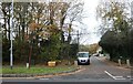
1
Pavement, A41 North Western Avenue
There is a lay-by here.
Image: © Robin Webster
Taken: 10 Jun 2015
0.14 miles
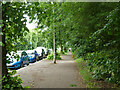
4
Harebreaks Wood Local Nature Reserve
Image: © M J Richardson
Taken: 26 Apr 2010
0.24 miles
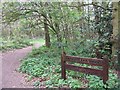
5
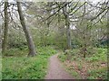
Harebreaks Wood
A local nature reserve in North Watford.
Image: © M J Richardson
Taken: 26 Apr 2010
0.25 miles