IMAGES TAKEN NEAR TO
St. Albans Road, WATFORD, WD24 6PR
Introduction
This page details the photographs taken nearby to St. Albans Road, WD24 6PR by members of the Geograph project.
The Geograph project started in 2005 with the aim of publishing, organising and preserving representative images for every square kilometre of Great Britain, Ireland and the Isle of Man.

There are currently over 7.5m images from over14,400 individuals and you can help contribute to the project by visiting https://www.geograph.org.uk
Image Map (Loading...)


Getting Data...Please wait
Leaflet Map data © OpenStreetMap
Images are licensed for reuse under creativecommons.org/licenses/by-sa/2.0
Notes
- Clicking on the map will re-center to the selected point.
- The higher the marker number, the further away the image location is from the centre of the postcode.
Image Listing (7 Images Found)
Images are licensed for reuse under creativecommons.org/licenses/by-sa/2.0
Image
Details
Distance
2
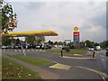
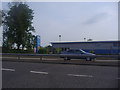
Shell Filling Station, Dome Roundabout, Garston
This filling station has an enormous open forecourt. There are two other stations on or near the Dome Roundabout which is visible in the distance. This makes prices here always very low.
Image: © Graham Hale
Taken: 14 Oct 2009
0.17 miles
3
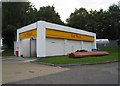
Car wash in Garston
On the A412, St Albans Road.
Image: © Mr Ignavy
Taken: 24 Sep 2010
0.17 miles
4
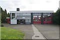
Garston fire station
Garston fire station, 530 St Albans Road, St Albans, Hertfordshire
Image: © Kevin Hale
Taken: 12 Nov 2006
0.19 miles
5
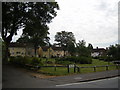
Fuller Gardens, North Watford
Off Fuller Road. Built pre-war for council housing.
Image: © Ray Stanton
Taken: 28 Jun 2006
0.21 miles
7
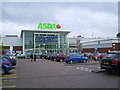
Main entrance to Asda / Walmart Hypermarket , Watford
This giant store is open 24 hours a day. Local road signage refers to it as a hypermarket.
Image: © Graham Hale
Taken: 6 Oct 2009
0.25 miles