IMAGES TAKEN NEAR TO
The Harebreaks, WATFORD, WD24 6NL
Introduction
This page details the photographs taken nearby to The Harebreaks, WD24 6NL by members of the Geograph project.
The Geograph project started in 2005 with the aim of publishing, organising and preserving representative images for every square kilometre of Great Britain, Ireland and the Isle of Man.

There are currently over 7.5m images from over14,400 individuals and you can help contribute to the project by visiting https://www.geograph.org.uk
Image Map (Loading...)


Getting Data...Please wait
Leaflet Map data © OpenStreetMap
Images are licensed for reuse under creativecommons.org/licenses/by-sa/2.0
Notes
- Clicking on the map will re-center to the selected point.
- The higher the marker number, the further away the image location is from the centre of the postcode.
Image Listing (8 Images Found)
Images are licensed for reuse under creativecommons.org/licenses/by-sa/2.0
Image
Details
Distance
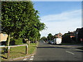
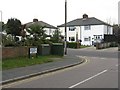
2
Gammons Lane
From its junction with Leaford Crescent
Image: © M J Richardson
Taken: 26 Apr 2010
0.13 miles
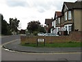
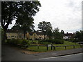
4
The Harebreaks, North Watford
Harebreaks Recreation Ground is on the left.
Image: © David Howard
Taken: 6 Sep 2012
0.16 miles
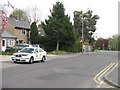
5
Leaford Crescent, junction with Gammons Lane
Image: © M J Richardson
Taken: 26 Apr 2010
0.18 miles
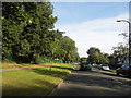
6
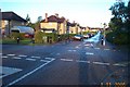
Watford: Fuller Road
Fuller Road viewed looking north westwards from the junction with Longspring, this road and the housing are typical of the northern half of the area in the grid square.
Image: © Nigel Cox
Taken: 1 Nov 2005
0.21 miles
7
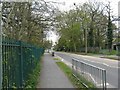
Leggats Way, North Watford
By the entrance to the Harebreaks Local Nature Reserve.
Image: © M J Richardson
Taken: 26 Apr 2010
0.23 miles
8
Fuller Gardens, North Watford
Off Fuller Road. Built pre-war for council housing.
Image: © Ray Stanton
Taken: 28 Jun 2006
0.25 miles