IMAGES TAKEN NEAR TO
Marri Street, WATFORD, WD24 5GB
Introduction
This page details the photographs taken nearby to Marri Street, WD24 5GB by members of the Geograph project.
The Geograph project started in 2005 with the aim of publishing, organising and preserving representative images for every square kilometre of Great Britain, Ireland and the Isle of Man.

There are currently over 7.5m images from over14,400 individuals and you can help contribute to the project by visiting https://www.geograph.org.uk
Image Map (Loading...)


Getting Data...Please wait
Leaflet Map data © OpenStreetMap
Images are licensed for reuse under creativecommons.org/licenses/by-sa/2.0
Notes
- Clicking on the map will re-center to the selected point.
- The higher the marker number, the further away the image location is from the centre of the postcode.
Image Listing (89 Images Found)
Images are licensed for reuse under creativecommons.org/licenses/by-sa/2.0
Image
Details
Distance
1
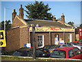
Watford: The old railway station house
In terms of railway history this insignificant little building is very important as it was the original station in Watford, dating from 1837 when the first section of what was to become the London and Birmingham Railway was opened. Intending passengers would enter through the front door and go down a flight of steps to the trackside level to board their trains. It was in use for only a short period of time as the hemmed-in site could not support the longer platforms necessary to accommodate newer and longer trains, and by 1860 the station on the site of the current Watford Junction station to the south of St Albans Road had been built and opened. Fortunately the building is Grade II listed and although in use as a car sales office it appears in good external order.
Image: © Nigel Cox
Taken: 21 Sep 2008
0.02 miles
2
Dunnings Bar on St Albans Road, Watford
Image: © David Howard
Taken: 20 Aug 2020
0.02 miles
3
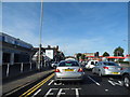
St Albans Road at the junction of Bedford Street
Image: © David Howard
Taken: 6 Sep 2012
0.02 miles
4
Radio mast by the West Coast Main Line, Watford
Image: © N Chadwick
Taken: 19 Dec 2010
0.04 miles
5
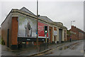
Former Bus Garage, Leavesden Road (2)
This photo shows the former bus garage in Leavesden Road WD24 5EB, at the junction with Copsewood Road. Following closure by London Transport in June 1952, this site was used for other purposes. However, it is in the course of being redeveloped, with a mixture of homes and offices to be built here shortly.
Image: © David Hillas
Taken: 12 May 2015
0.04 miles
6
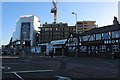
New construction on St Albans Road, Watford
Image: © David Howard
Taken: 20 Aug 2020
0.05 miles
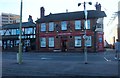
7
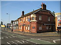
Watford: Dunnings Bar & Restaurant
This pub is in St Albans Road and was until recently The Stag as evidenced by the carving over the closed corner door. The pub dates from 1850 and was previously named the Bricklayers Arms and then the Queens Bays.
The half-timbered building beyond is also a pub, now known as The Champions, but once The Leviathan and before that The Leviathan Steamer. It dates from 1839.
Image: © Nigel Cox
Taken: 21 Sep 2008
0.05 miles
8
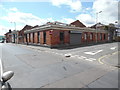
Former Bus Garage, Leavesden Road (1)
Situated in Leavesden Road near St Albans Road, this bus garage was opened on the 25th August 1920 by the London General Omnibus Company to operate bus services in the Watford area. However, it closed on the 17th June 1952 when LGOC's successor London Transport opened the bus garage at Garston, http://www.geograph.org.uk/photo/4622491 refers. Since then, it has been used for other purposes, but now it has been sold for redevelopment.
Image: © David Hillas
Taken: 12 May 2015
0.05 miles
9
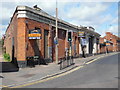
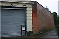
Former Leavesden Road bus garage, Watford
These premises stand on the corner of St Alban's Road and Leavesden Road and were opened as a bus garage in 1920 by the London General Omnibus Company. By 1952 the garage had become surplus to operating requirements and was closed that year by London Transport. Seen here is the part of the former garage that faces Leavesden Road.
Image: © David Kemp
Taken: 12 Nov 2012
0.06 miles
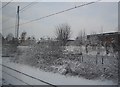
10
Former Leavesden Road bus garage, Watford
These premises stand on the corner of St Alban's Road and Leavesden Road and were opened as a bus garage in 1920 by the London General Omnibus Company. By 1952 the garage had become surplus to operating requirements and was closed that year by London Transport. The brick wall seen here forms the rear of the former garage and abuts a short alleyway that leads off Copsewood Road.
Image: © David Kemp
Taken: 12 Nov 2012
0.06 miles