IMAGES TAKEN NEAR TO
Cecil Street, WATFORD, WD24 5AS
Introduction
This page details the photographs taken nearby to Cecil Street, WD24 5AS by members of the Geograph project.
The Geograph project started in 2005 with the aim of publishing, organising and preserving representative images for every square kilometre of Great Britain, Ireland and the Isle of Man.

There are currently over 7.5m images from over14,400 individuals and you can help contribute to the project by visiting https://www.geograph.org.uk
Image Map (Loading...)


Getting Data...Please wait
Leaflet Map data © OpenStreetMap
Images are licensed for reuse under creativecommons.org/licenses/by-sa/2.0
Notes
- Clicking on the map will re-center to the selected point.
- The higher the marker number, the further away the image location is from the centre of the postcode.
Image Listing (26 Images Found)
Images are licensed for reuse under creativecommons.org/licenses/by-sa/2.0
Image
Details
Distance
1
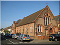
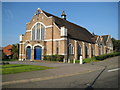
Watford: Leavesden Road Baptist Church (1)
Leavesden Road Baptist Church is at the junction of that road and Garfield Street. It is formed of this single Victorian building of 1895 surrounded by a later Edwardian extension in darker brickwork Image, with frontages onto both roads.
Image: © Nigel Cox
Taken: 21 Sep 2008
0.08 miles
2
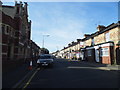
Leavesden Road, Watford
Leavesden Road Baptist Church is on the left.
Image: © David Howard
Taken: 6 Sep 2012
0.09 miles
3
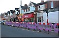
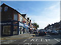
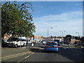
St Albans Road, Watford
Complete with covid barriers.
Image: © David Howard
Taken: 20 Aug 2020
0.09 miles
4
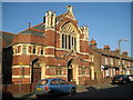
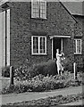
Watford: Leavesden Road Baptist Church (2)
This is the Leavesden Road frontage of the Edwardian extension to the original Victorian church Image The foundation stone of this extension was laid in 1909. The church was the subject of major refurbishment works between 1993 and 1996.
Image: © Nigel Cox
Taken: 21 Sep 2008
0.10 miles
5
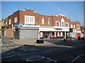
North Watford: Woolworths
A couple of unexpected urns decorate the parapet of this shopping parade, that includes Woolworths, in St Albans Road. The shop on the left is Propulsion Design and Print.
Image: © Nigel Cox
Taken: 21 Sep 2008
0.10 miles
7
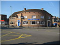
North Watford: The Verulam public house
Formerly The Verulam Arms the pub is on St Albans Road, hence the name, Verulamium being the Roman name for St Albans. The pub dates from 1957.
Image: © Nigel Cox
Taken: 21 Sep 2008
0.12 miles
8
North Watford Methodist Church
The church occupies a prominent position at the entrance to the Harebreaks estate and dates from the 1930s when this residential area was developed.
Image: © Nigel Cox
Taken: 21 Sep 2008
0.13 miles
9
The Harebreaks at the junction of St Albans Road
Image: © David Howard
Taken: 6 Sep 2012
0.13 miles