IMAGES TAKEN NEAR TO
Raphael Drive, WATFORD, WD24 4BD
Introduction
This page details the photographs taken nearby to Raphael Drive, WD24 4BD by members of the Geograph project.
The Geograph project started in 2005 with the aim of publishing, organising and preserving representative images for every square kilometre of Great Britain, Ireland and the Isle of Man.

There are currently over 7.5m images from over14,400 individuals and you can help contribute to the project by visiting https://www.geograph.org.uk
Image Map
Images are licensed for reuse under creativecommons.org/licenses/by-sa/2.0
Notes
- Clicking on the map will re-center to the selected point.
- The higher the marker number, the further away the image location is from the centre of the postcode.
Image Listing (54 Images Found)
Images are licensed for reuse under creativecommons.org/licenses/by-sa/2.0
Image
Details
Distance
1
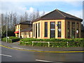
Watford: Centrepoint Community Centre
The Centre is on Brocklesbury Close at its junction with Raphael Drive, and has room for up to 50 people seated or 75 standing. It was built by Watford Borough Council in 1990.
Image: © Nigel Cox
Taken: 3 Apr 2010
0.00 miles
2
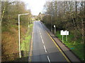
Watford: Orphanage Road
Viewed from the Brocklesbury Close overbridge, the Image is visible at the top of the hill.
Image: © Nigel Cox
Taken: 3 Apr 2010
0.05 miles
5

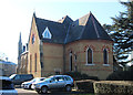
Watford: Former London Orphan Asylum Chapel
The Chapel dates from around 1870 and was built at a cost of about £5,000. The appearance of the building has been compromised by the loss of its tower from the right hand end at some time. A postcard from 1912 depicting the chapel shows the missing tower as a slender structure built in the same style and proportions as the two towers to the left, but larger and taller.
The building is Grade II listed and was converted into residential accommodation along with the rest of the former orphange around the 1980s.
Image: © Nigel Cox
Taken: 3 Apr 2010
0.12 miles
7
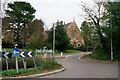
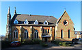
Watford
Reeds Chapel, now converted to residential accommodation.
Image: © Peter Trimming
Taken: 19 Nov 2022
0.13 miles