IMAGES TAKEN NEAR TO
Castle Close, BUSHEY, WD23 3LX
Introduction
This page details the photographs taken nearby to Castle Close, WD23 3LX by members of the Geograph project.
The Geograph project started in 2005 with the aim of publishing, organising and preserving representative images for every square kilometre of Great Britain, Ireland and the Isle of Man.

There are currently over 7.5m images from over14,400 individuals and you can help contribute to the project by visiting https://www.geograph.org.uk
Image Map
Images are licensed for reuse under creativecommons.org/licenses/by-sa/2.0
Notes
- Clicking on the map will re-center to the selected point.
- The higher the marker number, the further away the image location is from the centre of the postcode.
Image Listing (13 Images Found)
Images are licensed for reuse under creativecommons.org/licenses/by-sa/2.0
Image
Details
Distance
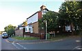
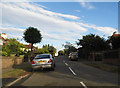
1
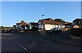
Herkomer Road at the junction of Castle Close
Image: © David Howard
Taken: 18 Sep 2019
0.01 miles
4
Coldharbour Lane at the junction of Melbourne Road
Image: © David Howard
Taken: 13 Sep 2012
0.09 miles
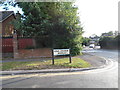
5
Herkomer Road at the junction of Koh-I-Noor Avenue
Image: © David Howard
Taken: 18 Sep 2019
0.09 miles
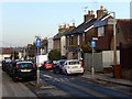
6
King George Avenue at the corner of Coldharbour Lane
Image: © David Howard
Taken: 13 Sep 2012
0.13 miles
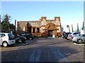
8
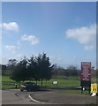
Entrance to Bushey Country Club
This access road leads from the A411 Bushey High Street towards the large club.
In the background is part of the golf course.
Image: © David Anstiss
Taken: 27 Jan 2013
0.14 miles
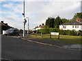
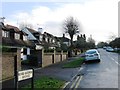
10
Park Road, Bushey
Residential street leading off Bushey High Street.
Image: © Stephen McKay
Taken: 16 Jan 2016
0.19 miles