IMAGES TAKEN NEAR TO
Meadow Road, BUSHEY, WD23 3FD
Introduction
This page details the photographs taken nearby to Meadow Road, WD23 3FD by members of the Geograph project.
The Geograph project started in 2005 with the aim of publishing, organising and preserving representative images for every square kilometre of Great Britain, Ireland and the Isle of Man.

There are currently over 7.5m images from over14,400 individuals and you can help contribute to the project by visiting https://www.geograph.org.uk
Image Map
Images are licensed for reuse under creativecommons.org/licenses/by-sa/2.0
Notes
- Clicking on the map will re-center to the selected point.
- The higher the marker number, the further away the image location is from the centre of the postcode.
Image Listing (10 Images Found)
Images are licensed for reuse under creativecommons.org/licenses/by-sa/2.0
Image
Details
Distance
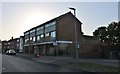
4
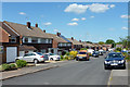
Cornfield Road, Bushey
It seems to be standard practice in this area to park half on the pavement.
Image: © Robin Webster
Taken: 7 Jun 2015
0.16 miles
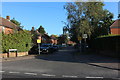
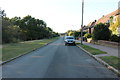
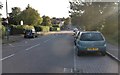
6
Bournehall Avenue at the junction of Moatfield Road
Moatfield Road is on the right
Image: © David Howard
Taken: 18 Sep 2019
0.19 miles
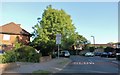
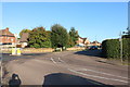
8
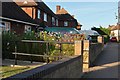
Bournehall Avenue, Bushey
I was drawn to the flowers
Image: © David Howard
Taken: 18 Sep 2019
0.20 miles
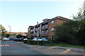
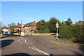
9
Bournehall Avenue, Bushey
Bournehall Primary School is on the left
Image: © David Howard
Taken: 18 Sep 2019
0.22 miles