IMAGES TAKEN NEAR TO
Royal Connaught Drive, BUSHEY, WD23 2RF
Introduction
This page details the photographs taken nearby to Royal Connaught Drive, WD23 2RF by members of the Geograph project.
The Geograph project started in 2005 with the aim of publishing, organising and preserving representative images for every square kilometre of Great Britain, Ireland and the Isle of Man.

There are currently over 7.5m images from over14,400 individuals and you can help contribute to the project by visiting https://www.geograph.org.uk
Image Map
Images are licensed for reuse under creativecommons.org/licenses/by-sa/2.0
Notes
- Clicking on the map will re-center to the selected point.
- The higher the marker number, the further away the image location is from the centre of the postcode.
Image Listing (23 Images Found)
Images are licensed for reuse under creativecommons.org/licenses/by-sa/2.0
Image
Details
Distance
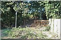
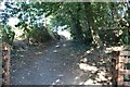
1
Bushey: Finch Lane
Formerly a road between Bushey and Aldenham Road, Finch Lane is now blocked off for traffic, and open for pedestrians only. It is viewed here looking northwards from the Bushey end.
Image: © Nigel Cox
Taken: 26 Nov 2005
0.08 miles
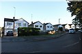
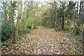
2
Finch Lane, Bushey
The old road has now become a path
Image: © David Howard
Taken: 18 Sep 2019
0.08 miles

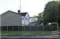
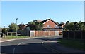
4
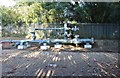
Gas installation on Finch Lane, Bushey
Image: © David Howard
Taken: 18 Sep 2019
0.09 miles