IMAGES TAKEN NEAR TO
Greatham Road, BUSHEY, WD23 2HT
Introduction
This page details the photographs taken nearby to Greatham Road, WD23 2HT by members of the Geograph project.
The Geograph project started in 2005 with the aim of publishing, organising and preserving representative images for every square kilometre of Great Britain, Ireland and the Isle of Man.

There are currently over 7.5m images from over14,400 individuals and you can help contribute to the project by visiting https://www.geograph.org.uk
Image Map
Images are licensed for reuse under creativecommons.org/licenses/by-sa/2.0
Notes
- Clicking on the map will re-center to the selected point.
- The higher the marker number, the further away the image location is from the centre of the postcode.
Image Listing (41 Images Found)
Images are licensed for reuse under creativecommons.org/licenses/by-sa/2.0
Image
Details
Distance
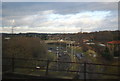
6
A4008 (Stephenson Way)
The Watford Inner Ring Road.
Image: © N Chadwick
Taken: 19 Dec 2010
0.15 miles
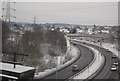
8
Path beneath the railway viaduct over the River Colne
Shows the location of Image
Image: © Mike Quinn
Taken: 15 Jan 2020
0.16 miles
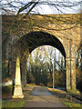
9
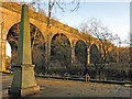
Railway viaduct over the River Colne (2)
Image: © Mike Quinn
Taken: 15 Jan 2020
0.16 miles
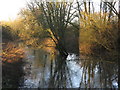
10
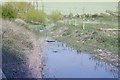
River Colne Waterfields Recreation Ground
View upstream from a position near the railway bridge, before landscaping of the river corridor was completed.
Image: © David Leeming
Taken: 10 Apr 1997
0.16 miles