IMAGES TAKEN NEAR TO
WD2 2LZ
Introduction
This page details the photographs taken nearby to WD2 2LZ by members of the Geograph project.
The Geograph project started in 2005 with the aim of publishing, organising and preserving representative images for every square kilometre of Great Britain, Ireland and the Isle of Man.

There are currently over 7.5m images from over14,400 individuals and you can help contribute to the project by visiting https://www.geograph.org.uk
Image Map
Images are licensed for reuse under creativecommons.org/licenses/by-sa/2.0
Notes
- Clicking on the map will re-center to the selected point.
- The higher the marker number, the further away the image location is from the centre of the postcode.
Image Listing (8 Images Found)
Images are licensed for reuse under creativecommons.org/licenses/by-sa/2.0
Image
Details
Distance
1
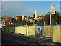
Vale Road, Bushey
A line of bungalows was demolished to make way for this new apartment block development along Vale Road, seen here from its junction with London Road.
Image: © Stephen McKay
Taken: 16 Jan 2016
0.17 miles
2
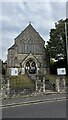
Bushey & Oxhey Methodist Church, Chalk Hill
Image: © Bryn Holmes
Taken: 12 Sep 2023
0.21 miles
3
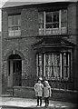
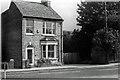
41, Aldenham Road, Bushey 1930
The wrought iron railings were removed to be melted down to help the war effort.
See also: Image
Image: © A.C.Burgess
Taken: 1 Jun 1930
0.21 miles
4
41, Aldenham Road, Bushey 1980
See also: Image
Image: © Antony Ewart Smith
Taken: 1 Aug 1980
0.21 miles
5
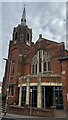
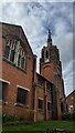
Bushey and Oxhey Methodist Church, Chalk Hill
Image: © Bryn Holmes
Taken: 12 Sep 2023
0.22 miles
6

Oxhey School, Empire Day, 1933
This school building stood to the right of Image and has now been demolished and rebuilt as apartments.
Image: © A.C.Burgess
Taken: 24 May 1933
0.24 miles
7
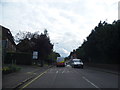
Aldenham Road, Bushey
Approaching Chalk Hill
Image: © David Howard
Taken: 30 Aug 2012
0.24 miles